For thousands of years, mankind has been navigating in a number of ways. From moss on trees, to the stars at night, we started with simple tools and ended up with complicated and complex devices. Today, in 2015, one of these complex and complicated devices is something that fits in our pocket. Specifically, the device itself is something that has almost transcended devices, in that it is not a device, but something that works on a device – in this case, an application. The complex and complicated device I am talking about here is Spyglass, an application that was designed for iPhones and other iOS devices. Spyglass is smaller than a smartphone, but make no mistake about it; you need a smartphone – in this case, an iPhone to use it. Even though Spyglass is small, the amount of information and data packed into its digital frame would make any of our ancestors who had to navigate from location to location jealous.
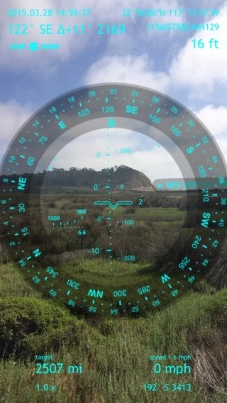
As I mentioned above, Spyglass is a navigation application for the iPhone; but calling it a navigation application is like calling a multi-tool a knife. Spyglass is more than a navigation application, it is the navigation application. What Spyglass is is an augmented reality navigation application, with the ability to overlay compass data, GPS data, speed data, declination data, and more over the iPhone’s visual range (camera) or over maps. If this sounds like a lot of data, it is. If this sounds like a compass, a GPS unit, and more packed into one application, it also is that as well. The application also, among other things, features the ability to track stars, and includes a sextant, inclinometer, and angular calculator. While I could go on for pages about the features of Spyglass, let me just say in short, that the application is using all of the modern iPhones (5 and up) features.
Personally, I find that while the features in this application – or any application range from the fantastic to the sublime, talking about such features as generalities leaves something to be desired in any review; and I would rather talk about my experiences with the application. In terms of full disclosure, I was contacted by Spyglass, and offered a free download of the application to test it out. Even though I like to think I am technically savvy person, I had not heard of Spyglass – positively or negatively – prior to being contacted by them, so I came into the review with a blank slate. In terms of my experience in navigation, in the event that you’ve never followed my blog, I am an avid explorer and outdoorsperson with over twenty-five years of experience in the backcountry.
The first thing that struck me about Spyglass after I downloaded it was that it is truly complex. This is not a simple point-and-click application, like Google Maps, or Apple Maps. This is something that is designed for actual navigation. This is also something that, if you are not familiar with Global Positioning Technology, Compasses, or other navigational tools, something that you will have to learn to use; and in all fairness, something that you will likely have to learn to use even if you are familiar with navigational tools. If you’re not interested in learning how to navigate, and expect something to navigate for you, this is not the application for you. Having said that, if you are willing to learn, and are interested in navigation, especially accurate navigation, or having the tools to ensure that you don’t get lost, this is the application for you. Even better, Spyglass has a great manual that provides everything you need to know about the application; whether you are a novice or an expert at navigation (you can find the PDF version here).
In terms of testing, I wanted to use the application in a variety of locations, both with and without coverage. I tried in areas with cell coverage – such as Torrey Pines State Reserve. While running along the beach, it consistently kept my location, and as an added bonus, logged my (at times slow) speed when I was running. I also tried it in areas with mixed coverage, such as the San Gabriel Mountains. Over the course of a ten mile hike to and from the Bridge to Nowhere, I was able to set waypoints, and find GPS coordinates. Finally, during the Shorty’s Well Traverse, I tested out the application in one of the most remote spots on the planet, Death Valley. Over the course of a forty mile hike through rugged terrain that lacked trails, I was able to use a majority of the application’s features, including the star/celestial finding features during the pre-dawn and post sunset hours.
On all of these occasions, I was impressed with how the application worked – I experienced no crashes or related failures – and how it responded. In terms of battery life, I didn’t feel during any of my tests that it drained battery any more than a comparable navigation application, but in terms of disclosure, I didn’t leave the application open for extended 20-30 minute time periods. Overall, even though the application had a learning curve, as I discussed above, I found it to be the best navigation application for the iPhone that is on the market, hands down. The range of features present in the application is truly stupendous, as well how the application performs. In an age where applications are constantly being installed and deleted on my phone, Spyglass is something that will stay on my phone permanently and something that I will use on an ongoing basis in the future – no matter where I am. Finally, if all of this wasn’t enough, let me also say that the camera feature on the application – which I used to take the above shots is also fairly cool; and Spyglass on Instagram has a great feed of wilderness shots to check out in connection with the application. Spyglass is currently $3.99 in the Apple Store.