Mill Creek, heading up Vivian Creek Trail, 6/2012
There’s something about San Gorgonio. I don’t know exactly what it is, but there’s something about it. There must be something about it, because I keep going back to climb it. There is one thing that I am sure about, however, and that is that the mountain doesn’t get any respect. In the mountaineering community, the summer ascent of San Gorgonio is written off as a mere “walk-up”, meaning that all you have to do is walk to the summit – no technical skill is required. While it is true that no technical skills are required to summit in the summertime, let’s talk statistics for a minute though: San Gorgonio is the highest mountain in Southern California at 11,502 feet. If you are taking the most popular trail, the Vivian Creek Trail, which I am discussing here, the trailhead elevation is 6,080 feet.
Moreover, according to the National Forest Service, from the Vivian Creek Trailhead, you will hike 9.3 miles one-way to reach the summit (more on distance at the bottom). This means that you will gain over 5,000 feet of elevation and walk over 18 miles to summit the peak and return. In order to summit San Gorgonio in the summer, you can also encounter a temperature range of 30 to 90 degrees. So, no, San Gorgonio is not the hardest, most technical peak to summit in the world. Then again, it’s not a cakewalk either. At the easiest, it’s a hard moderate hike; and in some respects, it is strenuous – so be prepared.
 Treeline, Vivian Creek Trail, 6/2012
Directions: The trailhead is located at the Forest Falls parking area. If you are coming from the West, you will take the I-10 East, and exit University Avenue, which you will follow for one mile, before turning right onto the CA-38, which at that point is signed as Lugonia Avenue. From that point, it is fourteen miles to the trailhead. Along the way, you will want to stop at the Mill Creek Ranger Station, which is located in Mentone to pick up two things: 1) A wilderness permit; and 2) A National Forest Adventure Pass. This is a popular hike (especially as it is right outside Los Angeles), and it is possible that you may not be able to obtain a permit if you are going on a weekend. However, reports of never being able to obtain a permit are exaggerations. Obviously, like any regulated trailhead, the day you are going, and the size of your group will affect whether you can obtain a permit or not. I’ve been going for years, and I’ve never had a problem; but I’ve also never had a group of larger than seven people. The good news about the permit is that it is free. One of the things that has changed about this hike is that the Forest Falls parking area now has a fee kiosk prior to entering the lot, and the Rangers do monitor the area for compliance, so you will need that $15.00 Adventure Pass for your car, unless you want a more expensive ticket!
From Forest Falls, the trail heads up past some inholdings, before crossing Mill Creek. Once you cross Mill Creek, the trail really begins, and the next mile of trail leading up to Vivian Creek Camp is steep. I’ve climbed steeper sections of trail; and longer sections of trail, but in my mind, this section is up there as one of the most difficult and steepest sections that I have traversed. Be sure that you pace yourself accordingly, as the remainder of the trail is also uphill, and you still have a long distance to go. After this section, you will be in a wooded valley next to Vivian Creek, and Vivian Creek Camp. The trail levels out slightly to pass through the valley, and winds up gradually to Halfway Camp. I always try to enjoy this section of the hike, as there is no gradual elevation gain from Halfway Camp to the peak.
 Summit, San Gorgonio, 6/16/2012
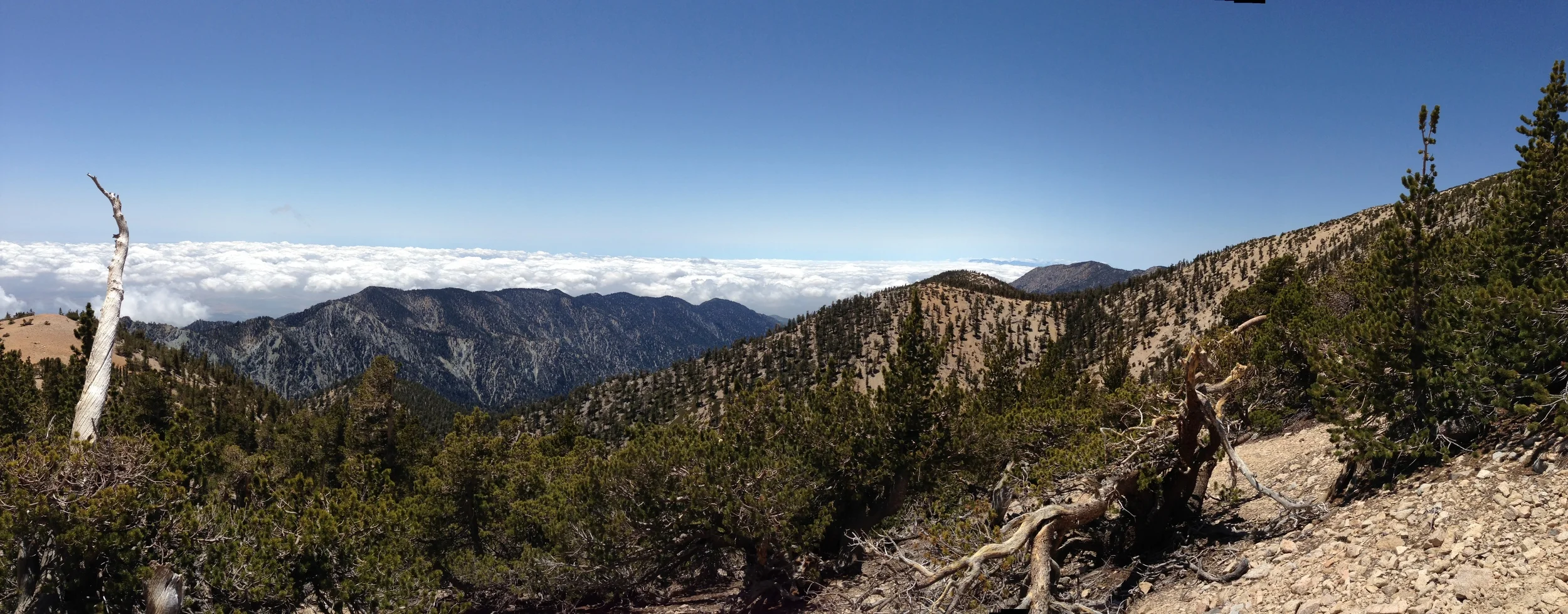
From Halfway Camp, there are a number of switchbacks that lead up to High Creek Camp; and then from High Creek Camp, there are a series of steeper switchbacks that lead you up to a ridgeline, where you will have clear unobstructed views of the peak, and the surrounding high country. At that point, there are a few remaining switchbacks that remain before you clear the treeline, but after that, it is a long steep ascent along the ridgeline up to the saddle just below the summit. Once you have attained the top of the ridge, you will be approximately half a mile from the summit, and have a negligible amount of elevation left to gain. After you have reached the summit, you will return the same way you came.
Current Conditions: I arrived at the Forest Falls parking area at around 7:25 a.m. on Saturday, and as I expected, the lot was nearly full at that point. Make no mistake about it, this is a popular hike, and should you arrive later in the day, you will risk not finding a parking spot. Since my gear was already packed, all I had to do was put on sunscreen, and I was ready to go. As it’s been a dry year, there was a negligible amount of water in Mill Creek – one foot wide, several inches deep; and I would not consider it a crossing at this point in time. Again, I can’t say it enough – that first section of trail up to Vivian Creek Camp is brutally steep, and I passed a number of people who were hurting/gassed on that section of trail on Saturday. While there was water flowing in Vivian Creek by the campground, it was flowing at a very low level, one that I would expect to see in late August or September. If I was to estimate, I would say that it will likely be dry within the next two weeks to a month. It’s also worth noting that I did not see any water flowing above Vivian Creek, so if you are backpacking or day-hiking, and plan to filter water; you should likely adjust your plans accordingly.
 Vivian Creek Trail, 06/16/2012
As for the rest of the trail, I’d say that it was in excellent shape the rest of the way up the mountain; and there were no obstacles that I saw to report or avoid. In terms of weather; as I got an early start, I avoided the heat from Mill Creek up to High Camp. However, it was very dry, and at or around High Camp, there were strong wind gusts of 25-30mph that persisted along the exposed traverse from treeline to the summit. These strong winds pelted me with all sorts of rocks, grit, and dirt; and at times, were physically pushing back against me on the ascent. There were also a few occasions, I felt like they were ripping the breath from my lungs. These winds made an already long day longer, as they were dry, which took more of moisture; and cold, which raised the potential for hypothermia (if I had not had the proper gear).
With respect to the second point, I saw a number of people who were not prepared for the cold – no jackets, wearing shorts – who were really struggling with the conditions past treeline. As always, be prepared with the proper gear; and check the conditions before you go. There is no snow anywhere on the summit; nor anywhere near the summit. Again, past Vivian Creek, I saw no flowing water of any sort; so plan accordingly. I spent a little less time on the summit than planned (due to the wind); and headed back down after about twenty minutes. On the descent, it was hot at all elevations below Halfway Camp. It looks like it will be a long, hot, dry, summer, so be warned if you are attempting the mountain from this point on. Roundtrip time for me was 8:05 (excluding stops), which seems pretty good in retrospect, but seemed slow at the time, but it was still a good day. At this point, I cannot reiterate enough: carry plenty of water if you attempt this hike during 2012, as it will be dry and hot!
Distance: It may surprise you, but the jury is out on how long this hike actually is. I spent a lot of time ruminating about this in 2010 (http://lastadventurer.com/last-adventurers-fieldnotes/2010/8/19/san-gorgonio-july-31-2010-vivian-creek-to-summit-156-miles-r.html); but the point is that it is a long hike. Summitpost lists it at 7.8 to 8.4 miles one way (http://www.summitpost.org/vivian-creek/155752); Local Hikes lists it at 16 miles roundtrip (http://www.localhikes.com/Hikes/SanGorgonioviaVivianCreek_4472.asp); and the National Forest Service calls it 18.6 roundtrip (http://www.sgwa.org/Wilderness_Mileage.pdf). Someday, I’m going to have to use my own GPS on it, and find out for sure how long it really is but at this point, I’m becoming more and more inclined to call it 18.6 to 19.5 miles, as confirmed here: http://trailtrove.com/san-gorgonio-peak-via-vivian-creek-trail. In any event, be prepared for a long day (or series of days, if you backpack it), and to go at least sixteen miles roundtrip.
More Information: http://www.sgwa.org/trails2.htm, http://www.sgwa.org/trails.htm#wilderness_conditions, http://members.boardhost.com/sgva/, http://www.fs.usda.gov/recarea/sbnf/recarea/?recid=26575