Follow Me, I Won't Get You Lost!
This form does not yet contain any fields.
    Take A Look Around...
    1 Day Hiking Mt. Whitney 10 Essentials 2Solar Eclipse 2012 Adventure Stories Aguereberry Camp Angel Share Angel's Landing Angel's Landing Trail Ansel Adams Anza Borrego Anza Borrego Desert Anza Borrego State Park Anza-Borrego Desert Arizona Arroyo Tapiado Arroyo Tapiado Mud Caves Ashford Mill Backcountry Skiing San Jacinto Backpacking Badwater Banshee Canyon Beardpocalypse 2010 Beards Beards Make One Hot Beaver Creek Benson Big Sur Black Mountain Black Mountain Community Ranch Park Black Mountains Blimps Blue Sun Cave Borrego Springs Borrego Springs Dinosaurs Borrego Springs Metal Creatures Borrego Springs Pre-Historic Creatures Bright Angel Trail Bump-And-Grind Trail Bump-N-Grind Trail CA Desert App Cabazon Cabazon Dinosaurs California Highway 1 California Horned Lizard Camping Food Canyon Loop Trail Cardiac Hill Cardiff State Beach Carlsbad Carlsbad 5000 Caverns Caving Cedar Fire Cedar Ridge Changing tires Chapel of the Holy Dove Charcoal Kilns Charcoal Kilns Death Valley Cinder Cone Natural Area Cloud's Rest Coachella Valley Cold War Consultation Lake Corte Madera Mountain Cowles Mountain Crampons Crane Flat Crest Canyon Crest Canyon Del Mar Cross Country Skiing Cross Country Skiing Yosemite Cross Country Skiing Yosemite Valley Current Trail Conditions Mt. Whitney Curtis Howe Springer Cuyamaca Lake Cuyamaca Rancho State Park Cuyamaca State Park Dantes BM Dantes Peak Death Valley Death Valley Charcoal Kilns Death Valley Driving Fail Death Valley National Park Deer Del Mar Airport Del Mar Blimps Desert Devil's Golf Course Dinny the Dinosaur Dominator Shipwreck Don't Stare at the Sun you will go blind Dos Cabezas Dos Cabezas Siding Dripping Springs Driving Fail East Side Trail Eastern Approach Woodson Mountain Eastern Sierra Interagency Vistor Center Echo Canyon Eclipse Glasses Emerald Pool Encinitas Eureka Dunes Eureka Mine Father Junipero Serra Museum Flagstaff Folly Peak Foster's Point Four Mile Trail foursquare Garnet Peak Geminid Meteor Shower Geminid Meteor Shower 2011 Geminids George Van Tassel Ghost Towns Giant Sequoia Giant Sloths Gin Flat Loop Golden Canyon Good Mountaineering Karma Goodan Ranch Gowalla Gower Gulch Grand Canyon Grand Canyon National Park Green Valley Grizzly Giant Guillermo Pino Half Beards Half Dome Happy Isles Harper's Creek Harrisburg Ghost Town Hearst Castle Hi Fi Killers Hidden Canyon Highway 120 Highway 41 Highway 67 Highway 67 Sycamore Canyon Staging Area Hiking Hole-in-the-Wall Hole-in-the-Wall Petroglyphs Horseshoe Mesa Ice Axe Indian Hill Ink Spots Inspiration Point Inyo National Forest iPhone iPhone Apps Iron Mountain Jeffrey Pine John Muir Trail Julia Pfieffer Burns State Park June Climbing Mt. Whitney Kartchner Caverns Kartchner Caverns State Park Kelbaker Road Kelso Kelso Dunes Kendrick Park Kubla Kahn La Jolla La Orilla Trail Ladders Laguna National Forest Lake Las Vegas Xterra Trail Run Lake Manly Landers Leonard Knight Little Yosemite Valley Living With the iPhone Lone Pine Long Valley Los Penasquitos Lagoon Lunar Eclipse Lunar Eclipse 2011 Lunar Eclipse December 2011 Lusardi Loop Trail Maar Volcanos MAD Mahogany Flat Malibu Creek State Park Manly Beacon Man's Best Media Mariposa Grove Merced River Mesquite Flat Sand Dunes Meteor Showers 2012 Missile Silo Mission Hills Mission Trails Regional Park Mist Trail Mog Mogfest Mogfest 2010 Mojave Desert Mojave Desert Tortoise Mojave Desert Tortoise App Mojave National Preserve Montezuma's Castle Montezuma's Castle National Monument Mosaic Breccia Mosaic Canyon Mr. Rex Mt. Badly Skiing Mt. Hoffman Mt. Laguna Mt. Lawson Mt. San Jacinto Mt. San Jacinto State Park Mt. Whitney Mt. Whitney Conditions Mt. Whitney Gear Mt. Whitney Hiking Mt. Whitney Permits Mt. Whitney summit Mt. Whitney Trail Mt. Whitney Trail Crest Mt. Woodson Mud Caves Nevada Fall Niland North Ponto Beach Nothing is the same Obselida Observation Point Oceanside Ooh-Ahh-Point Outpost Camp Painters Path Trail Palm Desert Palm Springs Tram Panamint Mountains Partial Solar Eclipse 2012 Partington Cove Trail Paso Picacho Campground PCT Penny Pines Perris Jurassic Park Petroglyphs Pima Air and Space Museum Plushgun Presidio Park Pupfish Quadrantid Quadrantid Meteor Shower Ranchita Ranchita Yeti Ranchos Palos Verdes Ravens Red Cathedral Red Tide Refrigerator Canyon Ridge Trail Ring Loop Trail Rings Climb Rogers Peak Round Valley Saber-Tooth Tigers Sahuarita Saline Pool Death Valley SALT Salt Creek Interpretive Trail Salt Pool Death Valley Salvation Mountain San Diego County Hiking San Diego Hiking Clubs San Diego Red Tide San Diego Urban Legends San Dieguito Lagoon San Eliijo Lagoon San Elijo Ecological Reserve San Gorgonio San Gorgonio Wilderness San Jacinto San Jacinto Hiking San Jacinto Summit San Jacinto Trail Scotty's Castle Scout's Lookout Sentinel Dome Sentinel Dome Parking Area Sentinel Dome Trail Sentinel Dome Yosemite National Park Sequoia National Park Sinagua People Tuzigoot Skeleton Point Slab City Snow Conditions San Jacinto Snowshoeing Solana Beach Solar Eclipse Solar Eclipse 2012 South Kaibab Trail South Ponto Beach Spelunking Sphinx Moth SS Dominator START Steampunk Stonewall Peak Stovepipe Wells Village Stowe Summer Solstice Sweetwater River Sycamore Canyon Preserve Taft Point Tarantulas Tatooine Telescope Peak Tenaya Canyon That's What She Said The Beanery The DC The Grandview Trail The Hermit Trail The Integratron The Specials Tioga Road Titan Missile Titan Missile Museum TNF Trailhead Torrey Pines State Beach Torrey Pines State Park Torrey Pines State Reserve Torrey Pines State Reserve Extension Total Lunar Eclipse Townsends Long Eared Bats Trail Camp Trail Running Trailside Meadows Transit of Venus Trona Tunnel View Yosemite Tuzigoot Tuzigoot National Monument Ubehebe Crater Unimog Utah Valley Loop Trail Venusians Verde Valley Vernal Fall Vernal Falls Virgin River Vivian Creek Vivian Creek Trail Vivian Creek Trail Mileage Wag Bag Wag Bags Wagbag Walter's Wiggles Wawona Tunnel Wawona Tunnel Emergency Access What not to do Death Valley Wheel of Kama Wheel of War Where to view the 2012 Solar Eclipse White Deer of Mission Hills Whitewater Preserve Whitney Portal Whitney Portal Message Boards Whitney Portal Store Whitney Portal Trail Wildrose Peak Winchester Mystery House Woodson Mountain Woolly Mammoths Wreck of the Dominator Xanadu Xterra Black Mountain Trail Run Xterra Malibu Trail Run Xterra Mission Gorge Trail Run Yeti Yosemite Yosemite National Park Yosemite Valley YYosemite National Park Zabriskie Point Zion Canyon Zion National Park Zzyzx
    « Rogers Peak, Death Valley National Park | Main | East Side Trail to Harper's Creek, Cuyamaca Rancho State Park »
    Tuesday
    Feb212012

    Charcoal Kilns, Death Valley National Park

    The Charcoal Kilns Interpretive Panel

    Back in the near-distant past, after dinosaurs roamed the Earth, I decided that I wanted to climb Telescope Peak. At that point, I didn’t know much about Death Valley other than what I had read and researched. I know that this was truly a long time ago, perhaps during part of the dark ages, because I had gleaned most of my information from actual books and paper maps. I left after work for the desert, and by the time I reached Emigrant Canyon Road within the park, it was very late. As my car glided over the curvy pavement like a giant bat, my eyes drooped slightly. Suddenly, my high beams caught a glimpse of something grey, brown and large on the road. Automatically, my foot hit the brake before I could say “Blue Moon”. My SUV skidded on its antilock brakes for a split-second before coming to rest.

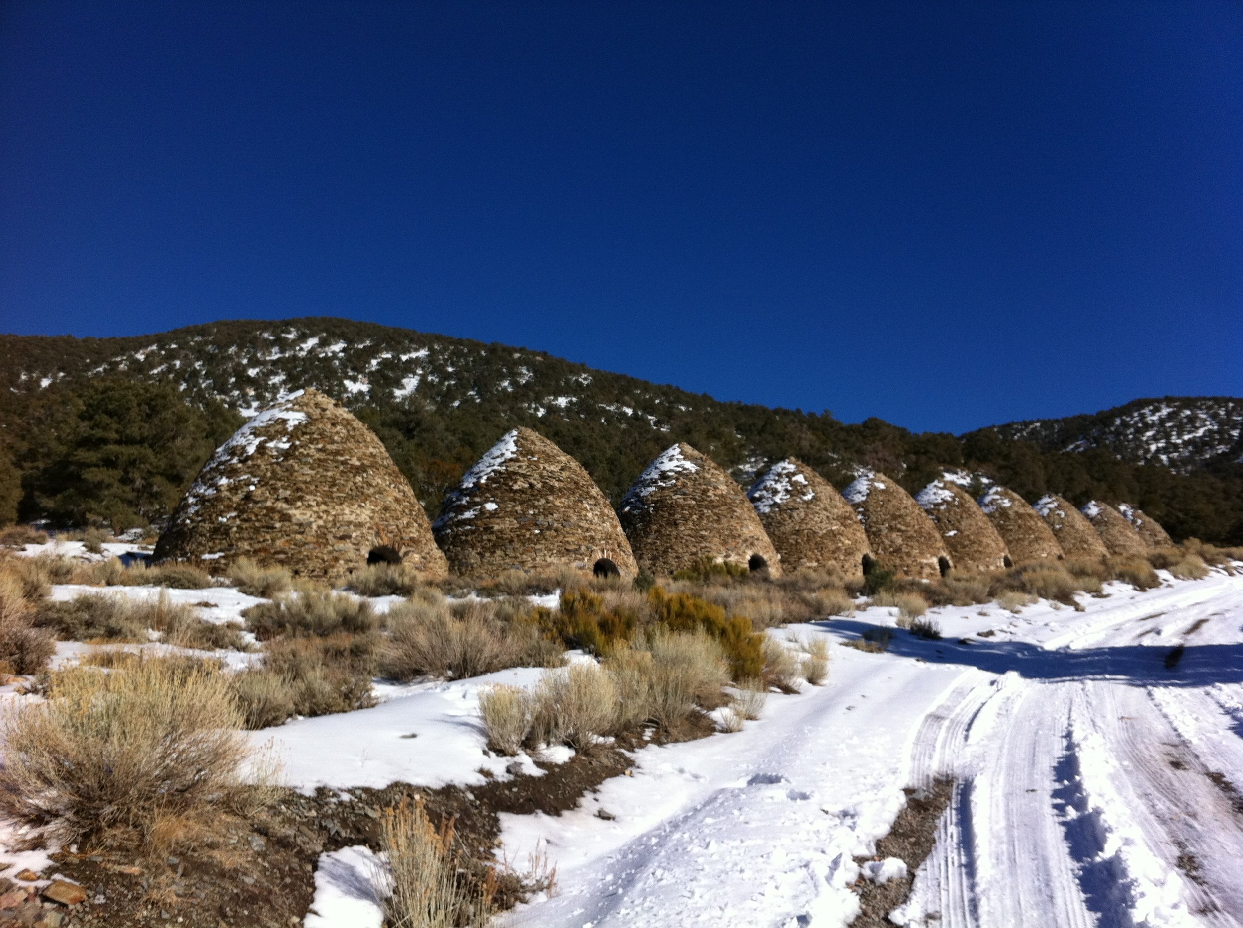
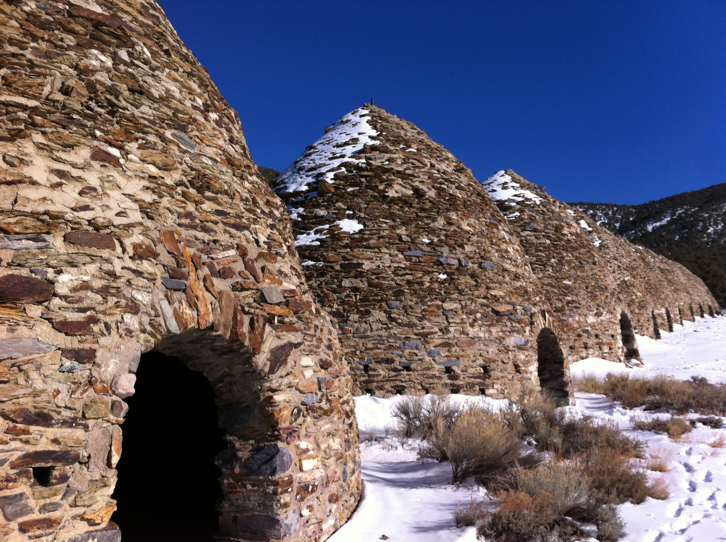
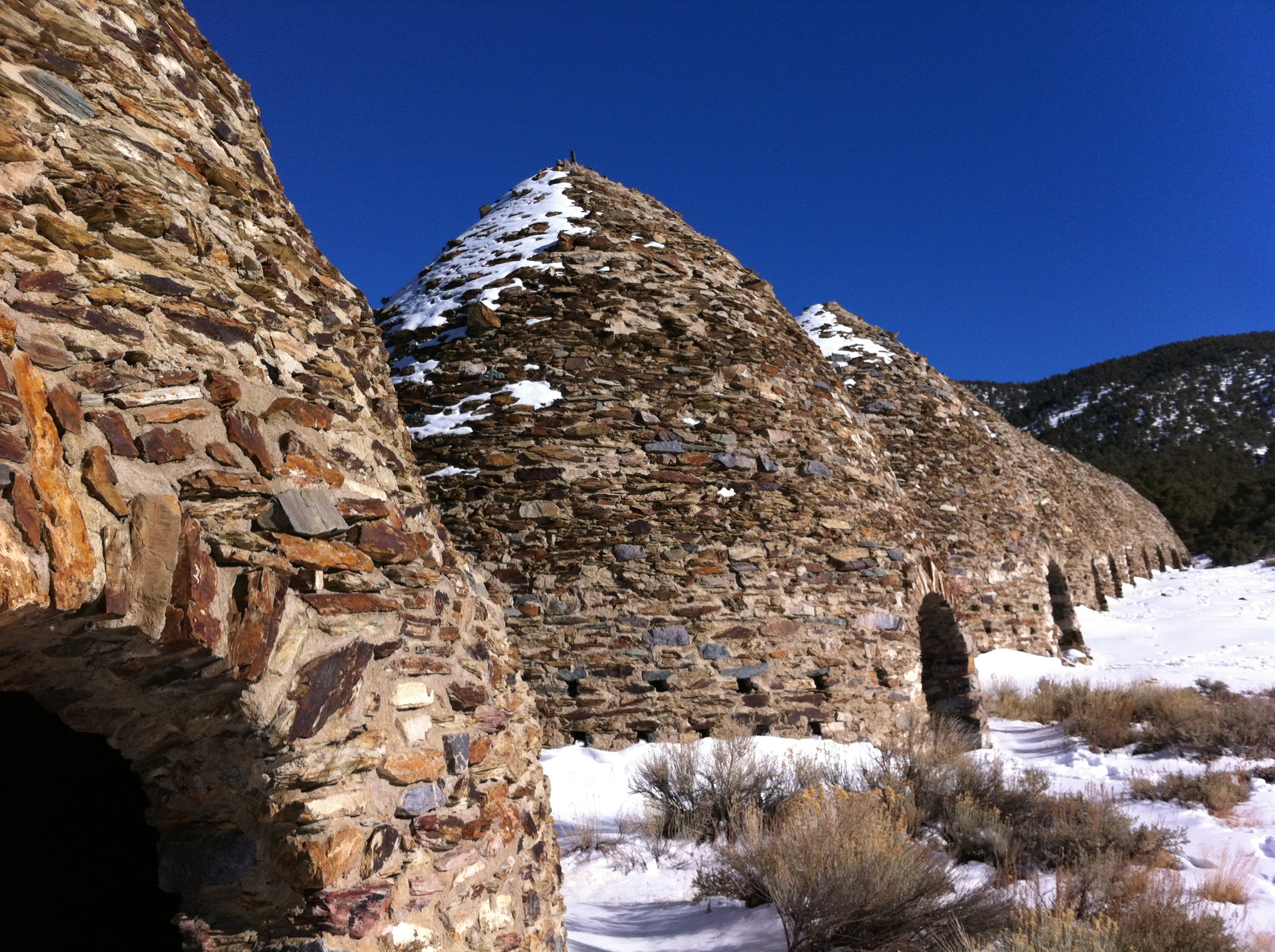
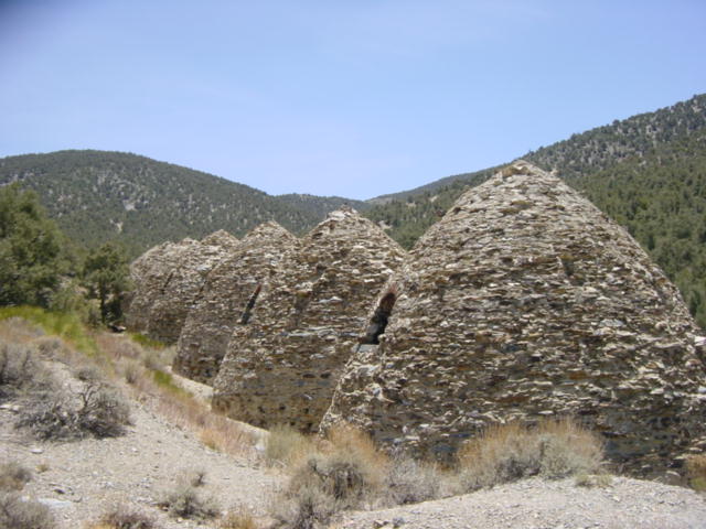
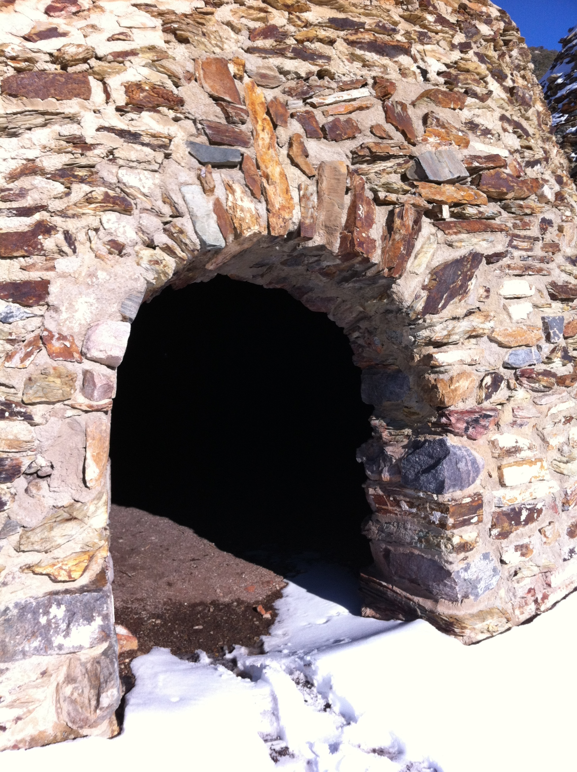
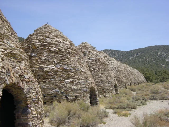
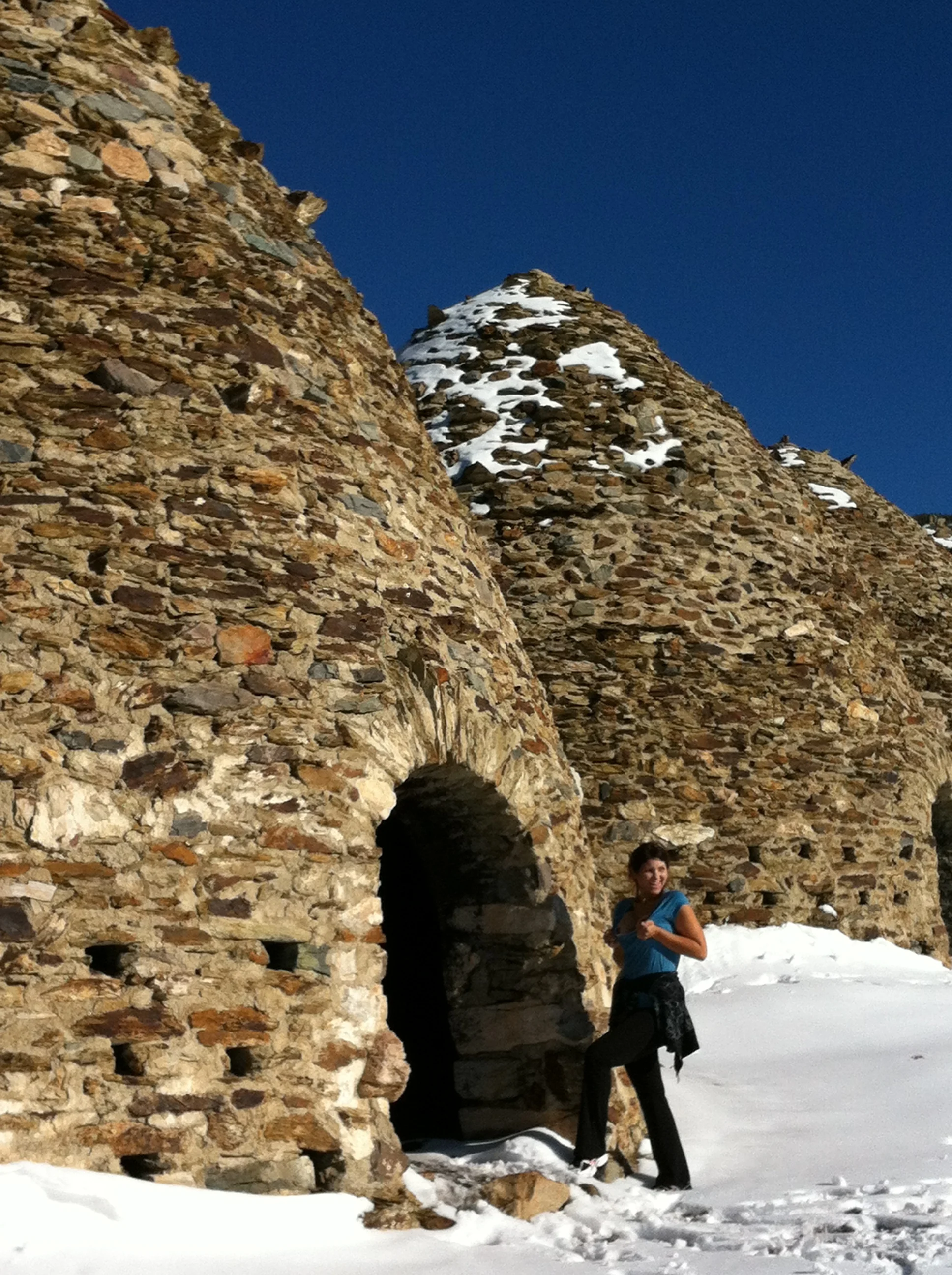
    Astonished, I stared at the herd of wild burros that were crossing the road in an utterly nonchalant manner. After that, I was awake. A couple of miles later, my breathing had slowed to a normal pace when my high beams again caught a glimpse of something off the road. I slowed and stared. It looked like there were…stone structures? I immediately rubbed my eyes. I knew that I was over twenty miles away from any sort of civilization. But yet, there were buildings there. I pulled off the dirt road, in case any burros needed to pass me at one in the morning, and stared. There were ten identical buildings, all made from stone, standing tall and silent in the night. Each stone dome had one door at ground level.


    Since I still couldn’t believe what I was seeing, I stopped the car, and crossed over the gravel to the nearest structure. Once inside, there was the distinctive faint odor of long burned fire, and a far window that let in the starlight.

    The Charcoal Kilns in winter (2012)

    After I stood there for a moment in the black silence, my mind started to wander to plotlines from every B-grade horror movie I had ever seen: strange structures in the desert; no one around; and an unwary lone wanderer potentially meeting a dire fate. I shuddered against the pre-dawn cold and my imagination and wandered back to my car, but not before giving the structures one last wary look. And that was the first time I went to the infamous Charcoal Kilns of Death Valley.

    Today, if I’m in Death Valley, I always try and stop by the kilns, because even though they may not have any role in a B-grade horror movie, they are interesting buildings from a lost world. Per the National Park Service, the kilns were constructed “…by the Modock Consolidated Mining Company in 1877 to provide a source of fuel suitable for use in two smelters adjacent to their group of lead-silver mines in the Argus Range west of Panamint Valley, about 25 miles distant from the kilns.” (http://www.nps.gov/deva/historyculture/charcoalkilns.htm).

    Charcoal Kilns in summer.

    I find it fascinating that these structures are still standing; and I also am amazed by the amount of work it must have taken to build and operate them in a location that is basically in the middle of nowhere. So, if you’re in Death Valley to climb some peaks, view the desert, or for any other reason, I highly recommend that you stop by the Charcoal Kilns, and write your own story involving them.

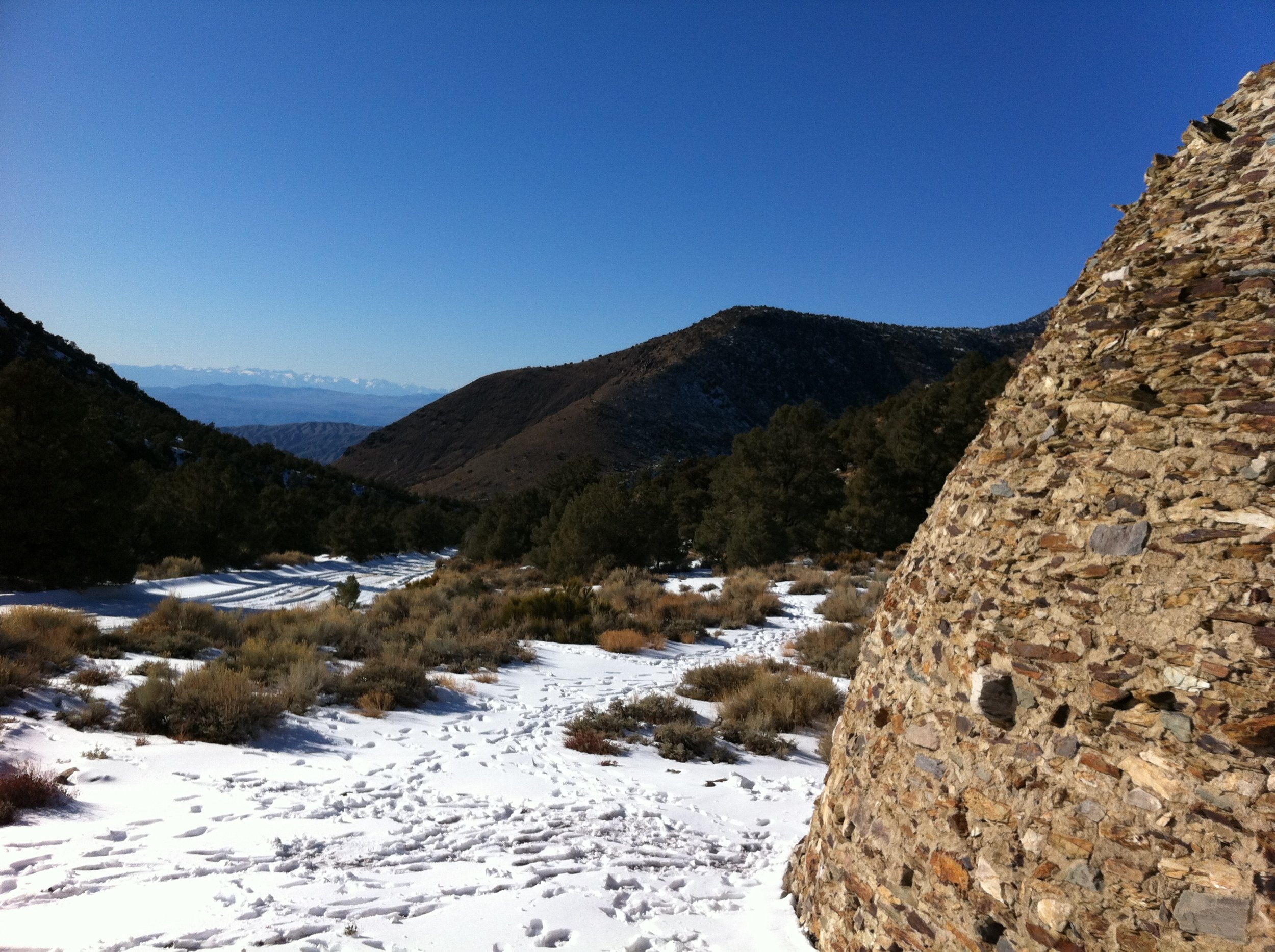
    Directions: Follow Emigrant Canyon Road for twenty four miles; after twenty one miles, the road is also known as Wildrose Canyon Road. At mile marker twenty four, the road becomes unpaved, and is mostly graded gravel. Follow this road for four more miles, and you will be at the kilns. There is no way to miss these structures from the road.


    Back of the Charcoal Kilns

    Tips: In wintertime, as pictured above, the last four miles of the road can become choked with varying amounts of snow and or ice, as well as runoff. Judge the conditions accordingly to determine if your vehicle can traverse the terrain without getting stuck.


    More Information: http://digital-desert.com/death-valley-history/wildrose-kilns.html, http://www.hikespeak.com/ca-desert/dv/charcoal-kilns-death-valley/, http://www.yelp.com/biz/charcoal-kilns-death-valley, (if you come in from Trona, you might have this reaction here, that I had: http://lastadventurer.com/last-adventurers-fieldnotes/2010/5/18/the-unexpected-lurks-everywhere-in-the-desert-from-factories.html)


     Charcoal Kilns, Winter 2012

    PrintView Printer Friendly Version

    EmailEmail Article to Friend

    Reader Comments (3)

    Leave the burros alone!!! LOL
    February 21, 2012 | Unregistered CommenterHeidi_J
    When was that snow up there?
    February 21, 2012 | Unregistered CommenterVrasi
    @Vrasi: that was last weekend, although snow at those elevations, even in Death Valley is common during the winter.
    February 22, 2012 | Registered CommenterLast Adventurer

    PostPost a New Comment

    Enter your information below to add a new comment.

    My response is on my own website »
    Author Email (optional):
    Author URL (optional):
    Post:
     
    All HTML will be escaped. Hyperlinks will be created for URLs automatically.