Round Valley, April 2011 (less snow here than May 2010!)
Although the backcountry skiing on San Jacinto is superb, what I like most about the peak is climbing it in winter. In fact, I’d go so far as to say that I prefer climbing the peak in the winter months over the summer months. While I have nothing against the summer route – and standard route that you loosely follow in the winter – I’d say the winter approach is a lot more fun. For starters, in the winter, you will likely have to find your own route after a certain point depending on the snow; there are less people; and in my opinion, the mountain is more scenic with a coating of ice and snow than it is in the summertime. There’s also no risk of dealing with extremely hot temperatures, dust; and if the conditions are right, you can glissade down the face of the mountain, which is a great rush, and an enormous time saver. I always make a point to head up to the summit of San Jacinto once a year (just to make sure it’s still there); and for the past two years, I’ve had great bluebird days on the peak in winter. As I’ve discussed the last two days, the snow this year is not what it has been, but I am sure I will head up to the summit at some point in the near future. From what I hear, you will still need crampons/microspikes at this point, even though the snow conditions are not optimal.
 Folly Peak to San Jacinto summit traverse (2011).
Directions: The easiest – and most accessible route is the same route that you would take in the summertime. The route starts from the Palm Springs Aerial Tram station in Long Valley. From the tram station, head into Long Valley, where you will pass the Ranger Station within a quarter mile. Remember, you will need a permit to head any further – but, don’t despair – permits are free! From the Ranger station, you will head up the trail (if it is visible) to Round Valley. At this point, where you head is a matter of where you want to go, and how your orienteering skills are. In 2010, I kept my group fairly close to the route of the actual trail (even though it was several feet below us in the snow); and in 2011 I elected to take my climbing partner and I up the face of Folly Peak after we branched off at Wellman’s Divide.
Alternatively, one could head straight for the summit prior to or at Round Valley; but in my opinion, the Folly Peak to San Jacinto traverse in winter is the way to go. Folly Peak is directly to the West of the San Jacinto summit; and clocks in at 10,480 feet. Last year, we traversed up to its summit in some fairly soft powder that was warming in the mid-afternoon sun. Once we were at the summit of Folly, we followed the more packed snow on the ridgeline over to the actual summit of San Jacinto, which was a little less than a mile. To get back to the tram, you can either walk back the way you came, or, if the conditions are right, like they were last year, you can glissade back down into Round Valley. This is exactly what my climbing partner and I did; we traversed back down to the rescue hut, and after checking it out – and the log, found a great spot to glissade down. I’d estimate that this way eliminated about two to three miles from our return trip; and was great fun, but there has to be enough snow to take this route (which at this point in 2012, it appears there is not). Distance wise, you can make this winter summit bid last around twelve miles if you really want, but realistically, if you know how to use a map and compass, or GPS, you’re looking at much less distance.
 Summit, San Jacinto, 2011
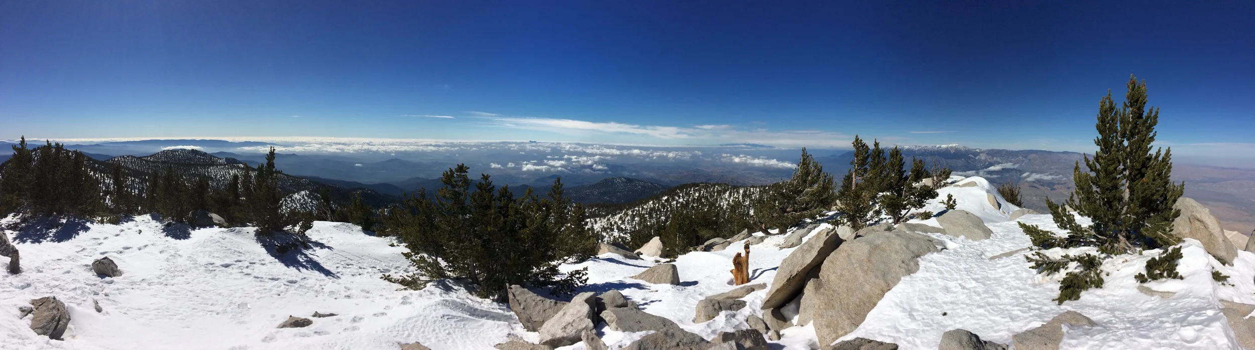
 San Jacinto summit, looking North to San Gorgonio
Tips: As noted in the last post, you’ll want the proper gear for this, in case the tram stops running; and because you are winter mountaineering. The summit does get hit pretty hard by strong winds, and the temperature can drop very fast. If you are going to attempt this in wintertime, I’d recommend one heads out mid-winter, rather than late winter. The difference? Firm footing that will involve less postholing than melting snow offers. If you are going to attempt this, do be familiar with your map/compass/GPS so as not to get lost. And finally, do note that John Muir did indeed say, “The view from San Jacinto is the most sublime spectacle to be found anywhere on this earth!” While I hate to disagree with Muir overall, what I will say is that if you do climb the peak in winter, you will definitely have a more sublime experience than the summer!
See you on the trail!
And...a view from the summit, here: http://youtu.be/uAwr5sMeW5A
More Information: http://www.parks.ca.gov/pages/636/files/MtSanJacintoSPmap.pdf, http://www.peakbagger.com/peak.aspx?pid=1480, http://angeles.sierraclub.org/hps/guides/27F.htm, http://www.summitpost.org/folly-peak/300638, http://en.wikipedia.org/wiki/San_Jacinto_Peak, http://lastadventurer.com/last-adventurers-fieldnotes/2010/6/6/san-jacinto-tram-to-summit-may-31-2010.html