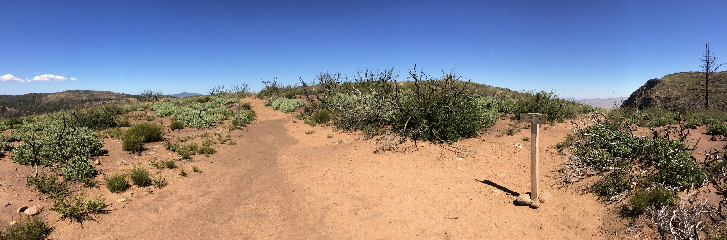
One of the best views off of the Pacific Crest Trail in San Diego can be found easily by through-hikers and day-hikers alike in the Laguna Mountains at Foster Point.
As you’ve seen above, #preservethegood could mean anything – it could mean helping someone in a time of need; it could be picking up trash on a trail, or a wilderness area; it could be educating people on leave no trace principles; it could be making a difference in any way you want; and it could be just about anything you want as long as you are focused in keeping the magic and the unique positive things in this world and this life. In terms of tangible things, I encourage you, my readers and followers to use the hashtag when you post a photo of something amazing; or when you’re talking about something exceptional you – or someone else has done to improve the world. I look forward to seeing how all of you end up preserving the good in 2015, and you can rest assured that as always, I will keep preserving the good where I find it as well, because as Plato says, “Good actions give strength to ourselves and inspire good actions in others.”
As I mentioned previously, Waimea Canyon is a site that is most definitely one of the “must-view” locations on Kauai, and in the world; and as I also mentioned, the best way to experience it is to hike it. While there are many great hikes through the canyon, the best hike in my book is the Canyon Trail to Waipoo Falls. It is the best hike to me because at four miles roundtrip, it is accessible, it has stunning views of the canyon from inside the canyon, and it ends at the top Waipoo Falls. It also allows the hiker the chance to swim in a waterfall, which is a once in a lifetime experience.
On July 5, 2013, I left work early, and headed up to Garnet Peak in the Cleveland National Forest to start my weekend with a short hike. It was a picture-perfect day with blue skies and since it was Friday afternoon, there was absolutely no one on the trail. The only downside on that day was the weather: it was hot , and the wind that rushed out of the Anza-Borrego Desert felt like an open oven. I remember feeling some of the plants and they were dry . Everything was tinder dry - not good for July in San Diego, where fire season lasts until October, or even November in drought years. Since I couldn't make it rain for the plants, I did the only thing I could: appreciated the natural beauty around me. Although I didn't know it, I was probably the last hiker to hike that area before it burned (photos here). On July 6, 2013, what became known as the Chariot Fire started, and spread through that portion of the Cleveland National Forest due to those dry conditions and high winds.
Heading South on the PCT to Foster's Point
Does this always look this beautiful? That was the question that kept rattling around in my head for the majority of my Friday hike. I had been asked that question a half mile into the hike, when I had passed the only other people that were on the trail. They were two backpackers heading to Mt. Laguna, and were only too happy to ask questions to catch their breath. I was happy to answer their question with a simple “yes” before I continued on, breaking trail for them and me to Foster’s Point. The question, however, stuck with me the majority of the day as I postholed through that section of the Pacific Crest Trail (“PCT”), while I thought about what I should have said to them, other than “yes”.
My problem with “Yes” was that it was, and is my stock answer whenever someone asks me if anywhere was that beautiful. It’s my stock answer, because, really, how am I supposed to answer that question? Am I supposed to be snarky, and say, “Nah, it’s extra beautiful today, just for you” or am I supposed to be negative, “No, not usually”. Instead of those two extremes, I always opt for honesty: every place is always that beautiful; it’s just that someone has to be there to see it and appreciate it; and subjectively wonder that human of questions: “is it beautiful”.
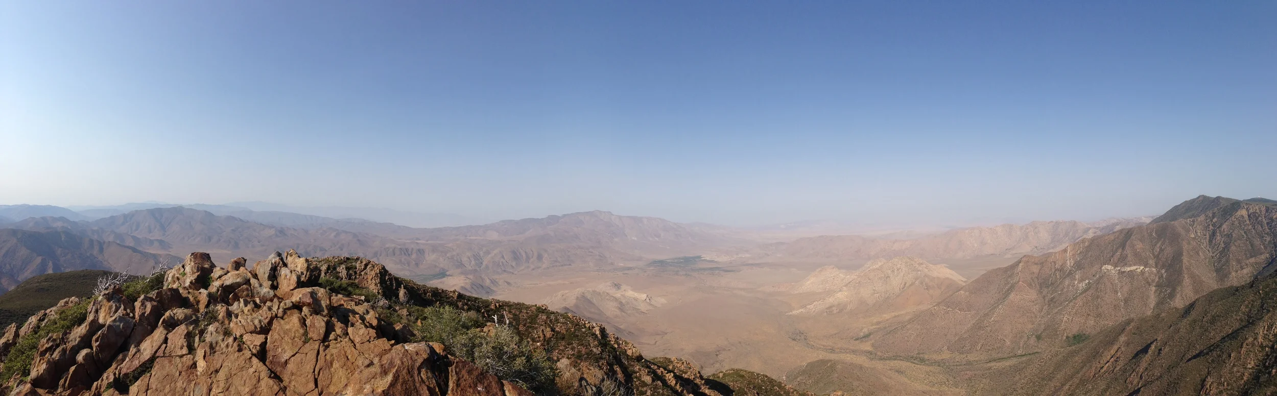
My thoughts on the trail from Penny Pines to Foster’s Point from that day, and other days are the following: this hike is on the edge of San Diego County off the S-1, the Sunrise Highway. The trail is literally on the edge of the Laguna Mountains, and from it, you can see what high forest San Diego County has to the West, while gaping at the tectonic drop off down to the Anza Borrego Desert in the East. From the desert floor, warm breezes cascade up and over the mountains, carrying hints of long lost geologic memories. The trail winds through quiet forests, and provides views of jagged peaks, and an observatory. Under the trees, you can smell the sound of the old growth trees of San Diego, making you wonder if you are still in Southern California at all. This is to say nothing of the other features that make this trail unique – of snow in winter, and dust in summer, and everything in between. But is it beautiful? I think so, because I keep coming back. If nothing else, it is unique, and that in itself is reason to do this hike. And that – along with, “except there’s not usually this much snow” is what I should have told the backpackers along with my simple “yes”.
Penny Pines, where the Trailhead is located for this hike.
Directions: Take the S-1, “Sunrise Highway” to the Penny Pines parking lot located at Mile Marker 27.3 off the road. (http://www.yelp.com/biz/pacific-crest-trail-at-penny-pines-pine-valley) There is parking on both the East and West sides of the road, but you will need a Forest Service “Adventure Pass”, which you can obtain at the Ranger Stations for $5.00.
From Penny Pines, head up the trail .1 miles to the junction of the PCT, and then head South (right) on the PCT. The trail initially drops down, giving you a good view of the desert floor, and Mt. Laguna. Within the first .10 miles after you join the PCT, there will be a hidden, wrecked Packard that is rusting out in the canyon. (Details in my previous post below, and is an interesting nugget to view should you see it). The trail continues due South for 1.6 miles, before heading up the side of Mt. Laguna. I’d rate this ascent as gradual, but as you are at around 5000 feet, you will definitely feel the climb. For this portion of the hike, you’ll be surrounded by clumps of manzanita, but no trees. At two (2) miles out from Penny Pines, you’ll see a wooden signpost directing you to Foster’s Point to your left (East). Follow the sign, and you will find yourself at a great overlook with views of Mt. Laguna, Garnet Peak, San Gorgonio on a clear day, and the Anza-Borrego Desert, of course! This is what it looked like on Friday, December 23, 2011: http://youtu.be/FR6uiAa-ptI
Foster's Point, December 2011
At this point, you can either continue on to Mt. Laguna, or head back to Penny Pines, and Garnet Peak. To do this loop without any side trips will run you a little under five miles round-trip (4.95 miles, to be exact).
Tips: Bring ample water, as this hike is very dry due to the desert winds that come up the canyons. Other than that, enjoy the hike, and the changing weather around it, as it can be done year round!
See you on the trail!
More Information:
http://lastadventurer.com/last-adventurers-fieldnotes/2010/11/22/the-good-the-bad-and-the-ugly-gowalla-foursquare-and-trailhe.html, http://www.signonsandiego.com/news/2010/jun/27/laguna-rim-views-take-your-breath-away/, http://www.sandiegoreader.com/news/2010/aug/04/roam-rama-foster-point/
Sitting atop Foster's Point - or am I?
“Come on you dirty rat bastard,” I swore at my phone as I watched the little data wheel turning slowly, “give me that good Edge network lovin’ – what the….awww, not again!” For the second time, foursquare had given me its fail message: “Your phone thinks you are too far away from Font’s Point, so no badges or points for you.” I stepped off Foster’s Point, cursed loudly to the clouds, grinned, and stepped back onto it. It was a beautiful day out on the Eastern Rim of the Laguna Crest. The warm desert winds of early fall were cascading up the canyons lining the mountains before pouring over the peaks and down into San Diego county. The yellow sun was warming trees, shrubs, rocks, and lone trail runners.
Lanky, high clouds strolled calmly across the pale blue sky. One could not ask for a more perfect day, especially with the smell of forest and new-old growth trees wafting around. I grinned again. I was in a fantastic spot with dramatic drop offs on one side, sloping mountains on the other, and I was focused on my mobile. I could only laugh at my ridiculousness. However, I was still slightly annoyed: I had created this location before. I had stood in this very spot. I had used this very phone. And yet, now, in the same spot, with the same phone, I was mysteriously too far away. I could only laugh. It was absurd. Not as absurd as spending part of my day staring at my phone, but still slightly absurd.
Let me backtrack a moment to explain why I was staring at my phone. I have an iPhone 4. It’s my second iPhone. When I purchased my first iPhone, my friend and fellow blogger K.Ho (http://iphoneliving.blogspot.com/) said to me, “It’ll change your life!” At the time, I had laughed at him. Two years later, I realize that he was right. Having an iPhone has changed my life. Unfortunately, while it hasn’t made me taller, wittier, more popular, or handsomer, its been a useful tool. There’s probably a discussion that could be had here about whether smartphones in general are good or bad things, but I’ll save that for a later date. If you have an iPhone or any type of smartphone, you’re aware that there are many applications that you can install on your device. If you’re not aware of this fact, guess what: there’s these crazy things called applications that you can install on your device that will allow you to get your money’s worth.
Mystery wreck...
This year, I started using foursquare (http://foursquare.com/). Foursquare is an application that uses the GPS feature on the phone to identify where you are, and allows you to “Check-In”. Checking in allows you to see reviews of the location, and allows you to see what other users are there, while collecting points and badges. I’ll be the first to admit it: foursquare is frightfully silly. But, it’s also a great deal of fun. Shortly after I began using foursquare, Rude Boy had told me about a similar application, Gowalla (http://gowalla.com/). Gowalla succinctly bills itself as a way to: “Keep up with your friends, share the places you go, and discover the extraordinary in the world around you.” In many respects, it is like foursquare, but one of the main differences is the ability to mark locations with photos you have taken, and to pick up and or put down virtual items. Personally, I’m a foursquare person for the most part, but Rude Boy is partial to Gowalla. I find whether you are a foursquare or Gowalla person depends on your individual personal preferences.
In general, the applications work great in cities where there is lots of cell coverage. In rural areas with little to no service, the applications, like your phone, do not work as well. After using these for a while, Rude Boy mentioned to me that the North Face had come out with a similar type of application, Trailhead (http://itunes.apple.com/us/app/trailhead/id380841551?mt=8), which was designed to provide people with the locations of trails in their area, and allow people to actively track themselves in the wilderness, while providing a readout of elevation gained, lost, and time spent hiking, while overlaying the results over a map of the area. If you’ve ever read this blog, or any part of this blog, or even just looked at the photos, you’d know this is the application for me. I downloaded it, and told Rude Boy that I’d try it out as soon as possible. In between discussing this with him and heading out, I decided that if I was going to test one application on the trail, I’d test a bunch of applications.
Because of this promise, I found myself on Foster’s Point cursing at my phone. Irrespective of whether I’m testing applications, one of my favorite training runs starts from Penny Pines (http://www.fs.fed.us/r5/cleveland/about/pennypines.shtml), heads South to Font’s Point, where I turn around, and head North, looping back over the first portion of the run, before angling out to a brutal uphill stretch up Garnet Peak (http://lastadventurer.com/last-adventurers-fieldnotes/2010/3/9/sunrise-january-1-2010-garnet-peak-california.html), and then back to the car. The run is a great way to decompress, and has a little of everything – single track forest terrain, rocky slopes and steep drop offs and great views of the desert and mountains. In order to make my tests as “difficult” as possible, I didn’t start using the applications until I was out on Foster’s Point.
Unfortunately, foursquare didn’t think I was on Foster’s Point. In order to see if this was a fluke, I jogged a little extra up the trail, and checked in at another location, before I doubled back and was again unable to check in. Gowalla didn’t know where I was, but it was perfectly happy to let me create a spot where I was at, and upload any photos, or drop any virtual loot that I wanted. I then opened up Trailhead, and after checking to make sure my Camelback was secure, began jogging back down my route.
Summit, Garnet Peak
After five minutes, I checked the application. The screen had a distinct line on the map of where I was, and where I had gone, and it seemed to be checking off how fast I was moving, and how much I had descended. Satisfied that it was at least working, I kept a tight grip on my phone, and kept running. At the secret abandoned wrecked Packard which is off that route, I stopped, exited the application, and paused my progress. I wandered off the trail, checked the wreck (still there and rusting), and re-started the application. It immediately picked up my location, and kept recording. I didn’t look at it again until I reached the top of Garnet Peak, where I again turned it off as I was taking my final break of the day. After listening to the sun burn and the universe whirl for a while, I turned it back on, and headed back down.
As I entered the parking lot at the end of the run, I checked Trailhead and found that it had tracked me the whole time, despite the interruptions I had imposed upon it. I was impressed. It had also noted that the run was 6.4 miles, which corresponded to how long I knew the trail to be. However, there were some gaps in its otherwise flawless coverage: for example, it stated that my pace had been -.7 miles per hour. I’m not sure how to take that. It either meant I was GIANT SLOTH SLOW (false), or I was the Flash Fast (also false, sadly). I was also a little suspicious of its total elevation gained and lost, until I realized that it meant cumulatively over the course of the hike, at which point I was again impressed. Overall though, I was the most impressed with its performance in rural areas. So, if you are like me and like to know what you are doing, and like to use your smartphone at times when perhaps, you would be better suited not using your smartphone, find my ratings as follows:
THE GOOD: TNF Trailhead. Kept an accurate reading of everything I did; and had a nifty feature that allowed me to save what I had done. THE BAD: Gowalla. Mainly “bad” because no locations were marked in the areas I was at. That’s a mild bad though, like a dirty car. Otherwise worked great. I even left some virtual loot for any other nerds at the top of Garnet Peak. THE UGLY: foursquare. Hate to say it, because I’m a big fan, but it refused to check me into two locations that I had created, even though I was standing in the exact same spot with the exact same phone. Not sure what that was all about. However, it treats me great in cities, so I can’t be that mad at it. And that is the roundup on location finding applications for Fall 2010.