Iron Mountain

Cedar Creek Falls

Cedar Creek Falls

Outside of the big three hikes in San Diego – “Potato Chip Rock”, Cowles Mountain, and Iron Mountain - the Cedar Creek Falls hike is one of the top five most popular hikes in the entirety of San Diego County. And, unlike many claims made about hiking in San Diego, this is not blogger hyperbole, this is a verified fact. The Forest Service website for the area even states that this trail is “...possibly the most traveled trail in the Palomar District”. As Cedar Creek Falls is so popular, no description of the hike would be complete without getting into why the trail and the waterfall is and has been so popular.

All-Star Adventure Guide to San Diego

All-Star Adventure Guide to San Diego

San Diego is a destination that is well-known for its fantastic weather, beautiful beaches, Comic-Con, and for being the home of Ron Burgundy in Anchorman. In addition to all of these things, San Diego is America’s Finest City and is the host city of the 2016 Major League Baseball All Star game. While Petco Park, the Convention Center, and the Gaslamp District are great spots in the city core of San Diego, the city, and the county as a whole have innumerable spots for visitors who have the time to explore, or who want to get away from the downtown crowds. Whether you are a first time visitor to San Diego, or a long-time fan of the city, check out the below destinations this weekend that prove that the city’s nickname is more than hype.

San Diego's Top 5 Mountains

San Diego's Top 5 Mountains

Irrespective of whether you’re a native Californian whose recently become interested in the outdoors, or a recent transplant that’s been hiking for years, you’ll find that San Diego has a number of fantastic trails and hiking opportunities. 

Mt. McGinty

Mt. McGinty

Case in point: McGinty Mountain – or Mt. McGinty. Like Iron Mountain, the roundtrip distance of this hike is 4.8 miles, and the while the elevation gained is slightly less, Mt. McGinty has two advantages: more rare plants and….a lot less people. Advantage: Mt. McGinty. Moreover, Mt. McGinty also has something Iron Mountain does not: hidden mines. Advantage again: Mt. McGinty. So, if you’re interested in a peakbagging experience in San Diego county that does not involve lots of hikers, read on.

A Devils Punchbowl but not "The" Devils Punchbowl

A Devils Punchbowl but not "The" Devils Punchbowl

Today I’d like to talk about the myth and legend of the “Devils Punchbowl” in San Diego County. If you’ve like me, and you’ve lived in San Diego, or spent enough time in San Diego, and you’re interested in the backcountry, chances are you’ve heard of “The Devils Punchbowl” after you heard about Cowles MountainIron Mountain, and Woodson Mountain (a/k/a “Potato Chip Rock”). Here’s the interesting thing though: unlike the above peaks, “The Devils Punchbowl” is a more nebulous concept. There’s no doubt that it exists – it’s definitely a location that exists. But, it exists in about ten or eleven different locations, depending on who you are talking to, and who is giving you directions to the “actual” site.

Trails of Santa Ysabel Open Space Preserve (West)

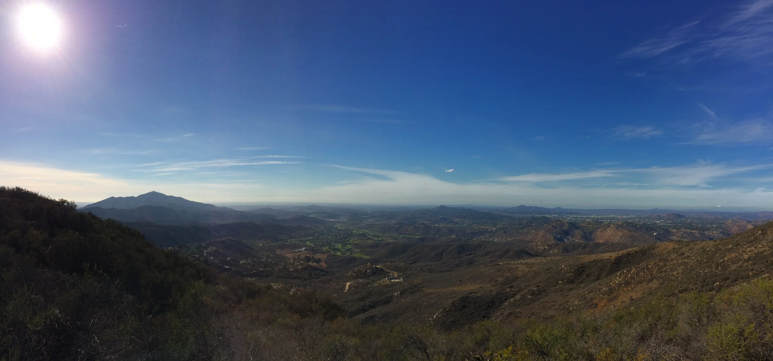
Lower Creek Trail, June 2012

Stop the presses. I have found the quietest place in San Diego County to go hiking. That’s right. There are many quiet places, but this place is the quietest. It is a place where silence is silent. It is a place where you can not only feel, but hear the sounds of grasshoppers bouncing off your shirt. It is a place where ground squirrels sound like lions crashing through the underbrush. It’s a place with a small babbling creek, a secret lake, and plants rustling in the afternoon breeze – but nothing else. It’s also a place that looks suspiciously like a “Happy Cow” commercial from the State of California. And, if you’re lucky, you too can visit it on a day when it is not that busy, because it is not that busy almost every day.

Directions: The Preserve is located one mile west of Santa Ysabel directly off of Highway 78 on the north side of the highway. If you are coming from the west on Highway 78, the Preserve is located thirteen miles east of Ramona. The entrance/parking area is clearly signed, and there is ample parking next to the trailhead, which leaves directly from the parking lot. The trail that leaves from the parking lot is the Lower Creek Trail, and it starts out level before gaining some elevation at around the half mile mark.

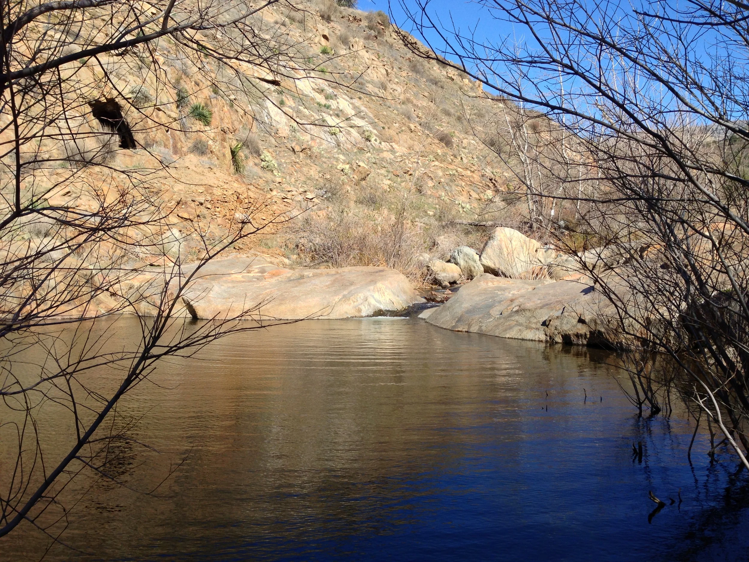
Oaks near Santa Ysabel Creek, June 2012

The trail then descends for a little over a mile down to Santa Ysabel Creek. During this time, there are excellent views of the surrounding terrain, as well as great views of the many Engleman’s Oaks that are in the Preserve, along with some California Oaks as well. At Santa Ysabel Creek, the Lower Creek Trail comes to an end after 1.8 miles. If you are a novice hiker, or just out for a walk, this is a great spot to turn around for an easy 3.6 mile roundtrip hike; although it is worth noting that there is a bit of elevation gain coming back up the trail from Santa Ysabel Creek (which may or may not be present, as it is a seasonal water source).

For a little extra effort, however, you can cross the Creek and you can continue on to either the Ridge Trail or the High Creek Trail for some more stunning views. From this point, it does not matter which trail you take, as they both connect via the Coast to Crest Trail or the Shortcut Trail in a small loop. From Santa Ysabel Creek, the loop is 2.1 miles total distance. When I did this hike yesterday, I headed up the Ridge Creek Trail initially, which had the advantage of providing me with all of the elevation gain for the hike during the first half of the loop, and which meant that I had great views of the surrounding area, and had great views of the secret lake/pond which exists slightly to the west of the intersection of the High Creek and Coast to Crest trails on my descent from the Ridge Trail. The total distance for hiking all of the trails in the Santa Ysabel Open Space Preserve (West) from the trailhead to the High Creek/Ridge Trail/Coast to Crest Trail loop is 5.7 miles roundtrip, and in my opinion, is a great hike to get away from everything.

 Secret pond at the Ridge Trail/Coast to Crest Trail Junction

Tips: As I mentioned above, I did this hike yesterday morning. As I drove up to Santa Ysabel, I passed Iron Mountain and its parking lot at 11 a.m. (http://lastadventurer.com/last-adventurers-fieldnotes/2012/2/11/iron-mountain.html). At that point, the parking lot was full, and there were a ton of cars on the side of the road. Look, I get it: Iron Mountain is a challenge, and is a great hike in its own respect. If you’ve never done it, and you want the satisfaction of attaining the summit, or you’re training for something, then, by all means, hike Iron Mountain. But, if you’re looking for actual quality time with Mother Nature, then I humbly suggest this network of trails (or the Sycamore Canyon/Gooden Ranch area: http://lastadventurer.com/last-adventurers-fieldnotes/2011/11/30/goodan-ranchsycamore-canyon-preserve-cardiac-hill-to-ridge-t.html). When I arrived at Santa Ysabel (West), there were no cars in the parking lot, and I saw no one on the trail. Let me repeat that for a second: there was no one else there. Solitude doesn’t get much better than that!

Other things you should know: right now, its summertime, which means it’s warm. Be sure to bring plenty of water, as it can get warm, and the oaks don’t provide that much shade. Also, the trail from Santa Ysabel Creek to the Ridge Trail/High Creek Trail is somewhat steep, so be ready for a short but steep ascent. Do also note that the Preserve is home to cows. Do not chase the cows, they will chase you, and they can and will run much faster than you. My suggestion: if you leave the cows alone, they’ll leave you alone. It’s a happy arrangement for all parties. Other than that, the trails are well marked, and well maintained, and enjoy the silence and beauty of the region.

More Information: http://www.co.san-diego.ca.us/reusable_components/images/parks/doc/SantaYsabelWest_Trails.pdf, http://www.co.san-diego.ca.us/parks/openspace/Santa_Ysabel.html, http://www.100peaks.com/2011/01/16/santa-ysabel-open-space-preserve-west-no-peaks-but-a-beautiful-hike/, http://www.utsandiego.com/news/2010/apr/18/santa-ysabel-west-is-a-foothill-adventure/?page=1#article

Recap of the Solar Eclipse of 2012 as viewed from Iron Mountain

Iron Mountain, 5/20/12

Good news: the Solar Eclipse of 2012 came and went yesterday, and the world did not end. As a result, we will now have to wait for the next big celestial event – the transit of Venus (the last one of the 21st century, FYI) to find out if indeed the apocalypse is happening. Fortunately, we do not have to wait long – this event will be occurring on June 5, and June 6 of this year. (http://earthsky.org/astronomy-essentials/last-transit-of-venus-in-21st-century-will-happen-in-june-2012). If by some fluke chance, the transit of Venus does not end all life as we know it on the planet, there will only be a few more months left until December 2012 comes along and provides a definitive answer on whether life on this planet will end this year. If not, there’s always next year with all of its associated predictions of doom and gloom to look forward to!

In San Diego, as the forecast for Sunday was for a coastal cloud layer up to approximately 1500 feet, I elected to take my group of eclipse viewers to higher ground atop the summit of Iron Mountain in order not to miss the show. I figured that at 2,696 feet, we’d be well above the cloud deck, and have a great bird’s eye view with our “Eclipse Glasses” that I had picked up from the Reuben H. Fleet Space Theater. (http://www.rhfleet.org/).

 The Infamous "Eclipse Glasses"

The Trail: I took my group up the standard Iron Mountain trail described here: http://lastadventurer.com/last-adventurers-fieldnotes/2012/2/11/iron-mountain.html. Not surprisingly, the trail had not changed at all since I had last been on it. We made good time up the trail, and there were no obstructions of any sort, nor any new developments on the trail that I can report for spring 2012. The City of Poway does a good job of keeping the trail clean and clear; so aside from several yuccas being consumed by hungry beetles, everything appears normal for this time of year. The only thing I will say about the hike was that as it is now late May, the temperatures are starting to heat up on the trail, so plan accordingly, bring plenty of water, and keep an eye out for rattlesnakes.

The Eclipse: While Iron Mountain has a good view from the summit, this view was obscured to the west yesterday by those aforementioned coastal clouds. And, while Iron Mountain has a good view, we there to see the eclipse, and it did not disappoint. Around 5:27 p.m., the moon slowly began to move in front of the sun, and for the next hour, my group and everyone else who made the hike had a great view of the phenomenon. While the summit did eventually fill up with people by around 6:30 p.m., at which point the sun was almost 83% covered, it was a sociable crowd which was willing to help one another by sharing pieces of welder’s glass, eclipse glasses, or other safe-sun viewing equipment and knowledge. There was even a telescope set up that could pick out sunspots on the visible portions of the sun, so if you were a science person, the summit was a good place to be.

 Cell phones: good for everyday use; not as good for eclipse photos. Especially when the battery dies!

Lessons Learned: First and foremost, while the Eclipse Glasses may have looked like something out of a bad 1950’s three-dimensional movie, they were very effective in protecting our eyes. In this respect, I am very pleased to report that none of my group went blind, so thank you Reuben H. Fleet science center. (Again: http://www.rhfleet.org/). In addition to preventing blindness, these glasses sold at an economical $2.00 per pair, which saved me the trouble of wandering around the county as some parties apparently did looking for welder’s glass. We also learned that while cell phones are great at snapping images of everyday life, they’re not so good for taking pictures of the eclipse (even when filtered through a set of eclipse eyeglasses). Other than that, it was an excellent time, and I’m sure I’ll be out for the next solar eclipse, because at those times, the sun and moon have the power to turn minutes into centuries.


Photos of the Eclipse: http://www.ibtimes.com/articles/343423/20120521/solar-eclipse-2012-photos-ring-fire-annular.htm, http://www.boston.com/bigpicture/2012/05/ring_of_fire_eclipse_2012.html