

Mount Whitney is one of the most iconic spots, and one of the most sought after peaks in the mountaineering community. At 14,508 feet (and growing), it is the tallest peak in the continental forty-eight states.
As you’ve seen above, #preservethegood could mean anything – it could mean helping someone in a time of need; it could be picking up trash on a trail, or a wilderness area; it could be educating people on leave no trace principles; it could be making a difference in any way you want; and it could be just about anything you want as long as you are focused in keeping the magic and the unique positive things in this world and this life. In terms of tangible things, I encourage you, my readers and followers to use the hashtag when you post a photo of something amazing; or when you’re talking about something exceptional you – or someone else has done to improve the world. I look forward to seeing how all of you end up preserving the good in 2015, and you can rest assured that as always, I will keep preserving the good where I find it as well, because as Plato says, “Good actions give strength to ourselves and inspire good actions in others.”
As I mentioned previously, Waimea Canyon is a site that is most definitely one of the “must-view” locations on Kauai, and in the world; and as I also mentioned, the best way to experience it is to hike it. While there are many great hikes through the canyon, the best hike in my book is the Canyon Trail to Waipoo Falls. It is the best hike to me because at four miles roundtrip, it is accessible, it has stunning views of the canyon from inside the canyon, and it ends at the top Waipoo Falls. It also allows the hiker the chance to swim in a waterfall, which is a once in a lifetime experience.
Current Conditions Mt. Whitney
Bad. That is the state of California’s mountain snowpack as of today, January 20, 2014. In fact, bad probably is an understatement. A more accurate descriptor might be “awful” or “horrible”. You may think I’m exaggerating – but I’m not. One of the things that’s been lost in the winter of 2013-2014 among “polar vortexes” and wind chill is the simple fact that in California, winter has ceased to exist. While California has always popularly been known as the land of Endless Summer, it used to have seasons. While our seasons were milder than say, Pennsylvania, the state did have them – but not this year. In cases like this, I find a picture is worth a thousand words. If you look down, you’ll see the picture that Governor Brown featured in his press conference from the National Oceanographic and Atmospheric Institution regarding the conditions from 2013 to 2014.

On the left, you can see the snowpack as it was in 2013 – a drought year, but a more “normal” year than 2014. On the right, you can see the snowpack as it stands now. Again, keep in mind that California is a state that should have winter. California is also a state that should most definitely have snow above 8,000 feet during the winter months – and yet it does not this year. In Yosemite, the Badger Pass ski area is closed, because there is not enough snow. On Mt. Shasta, rescue crews had to aid two climbers on one of the more popular routes of the mountain, because, among other things, the route did not have enough snow. And, on Mt. San Jacinto, there is no snow at all.
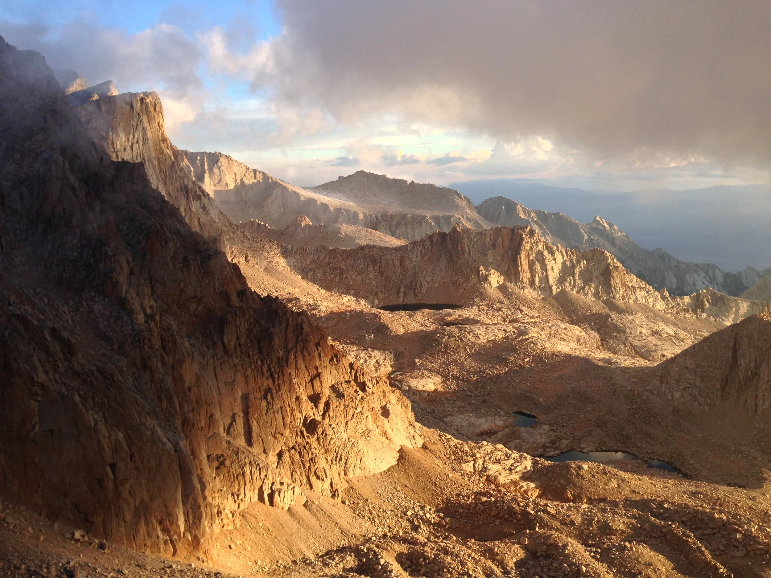
Western Sierra Nevada Mountain Range from Mt. Whitney, June 2011
The cause of the worst winter in recorded history since 1890 is a “blocking high” – a high pressure dome which diverts storms from the state during the state’s wettest months. But this blocking high is part of a larger problem in California, which is a persistent multi-year drought. As a mountaineer, I’ve observed the climate change over the last five years in our tallest spots. I’ve watched the glaciers recede on Mount Shasta over a ten year period.
Western Sierra Nevada Mountain Range from Mt. Whitney, May 2012
I’ve also watched the Sierras progressively receive less and less snow during the recent years. In 2010, I climbed Mt. Whitney on the summer solstice under bluebird conditions with snow and ice. In 2011, I climbed Mt. Whitney a week earlier, only to find that it has less snow than 2010. In 2012, I again climbed Mt. Whitney a week earlier – to find that it had no snow. In 2013, when I went to Mt. Whitney in mid-April, most of the snow was melting off. This year, the mountain by and large has little to no snow. Think about that for a second: the highest point in the continental United States has little to no snow in wintertime.
I could provide even more examples, and in some cases, even more pictures of what I’ve seen in California’s mountains over the last ten to fifteen years, but there’s no point in providing them here. Either I’ve convinced you – or you were already convinced that climate change is occurring; or either I’ve not convinced you – and you never were convinced that such a thing exists. For me, I am convinced – and I have been convinced for a long time, based on what I’ve seen that the climate is changing. If you don’t agree with me, I will paraphrase Voltaire and state that I agree with your right to disagree. What I will also say is this: even if you don’t believe in climate change, it’s already affecting you – especially if you live in California, from water use regulations, to wilderness use regulations, and expanded and unprecedented wildfire seasons and durations. (More info on the drought here, here, and here).
As for what the future holds, no one – including myself knows. But what is clear in the present is that 2014 will likely be one of the worst – if not the worst mountaineering season in terms of winter conditions. In most areas, climbers will not need ice axes or crampons. What climbers will need, however, is good real time knowledge of conditions as they are now, not as they have been for years. This is something I discussed with @thepeakseeker and @mikburtula on the last episode of IIAWT, and it is something that all potential climbers should be aware of; especially on such iconic routes as the Mountaineer’s Route on Mt. Whitney, or the Avalanche Gulch route on Mt. Shasta, because it is clear that without fresh or new snow, these routes, along with others, may be impassable. In such times of drought and change, more than ever the axiom “be prepared” is and will be particularly applicable; and until it happens, let us all pray for snow, because winter is more than overdue.
And, If you're scientifically inclined, you can check out the day to day water reports from DWR here.

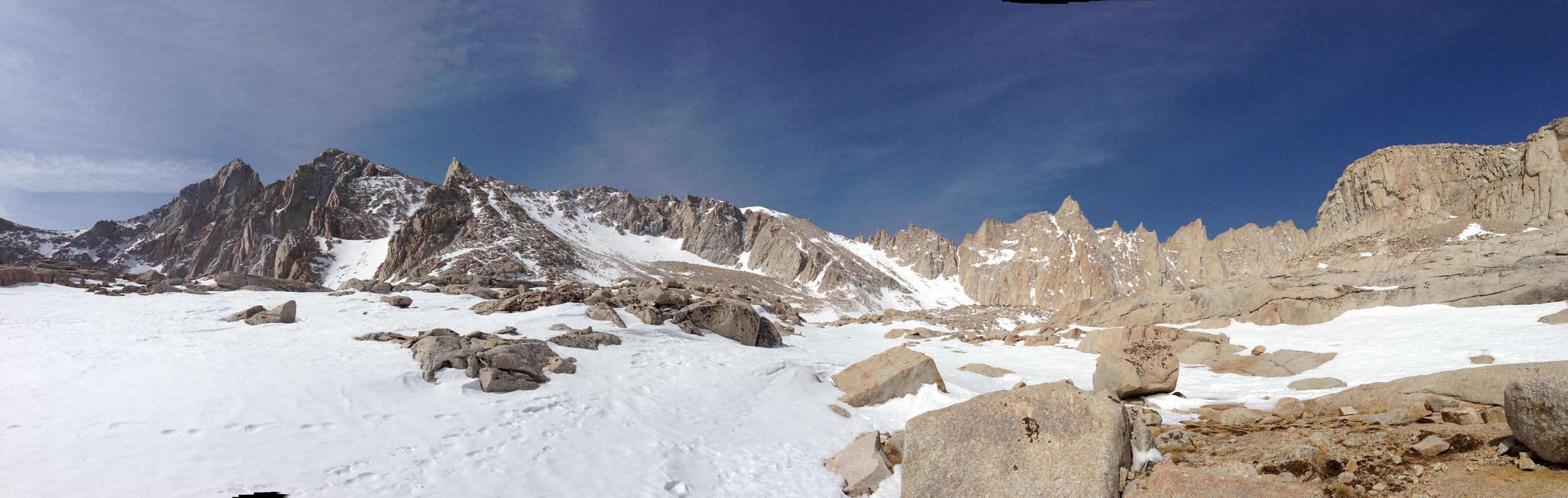
First "serious" snow, near Lone Pine Lake, Mt. Whitney Trail, April 8, 2013
Every year, I like to take a trip up to Mt. Whitney, either to climb the mountain, or to hike around the general region, as it is stunning. This year, I had to make my trip a little earlier than usual due to a combination of factors; but also to get in some ice axe and crampon practice for my upcoming climb of Mt. Rainier, which my climbing and podcast partner, Matt Mills and I will be climbing the first week of May. If you’ve ever read my blog, you know that I always have additional commentary about things that I think about while hiking, which I’ll reserve for tomorrow; but for today, just the facts regarding trail conditions as of Sunday, April 8, 2013.
Trail Conditions: The road up to Whitney Portal is almost completely clear of all obstacles. There were some small rocks/boulders in the middle of the road; and there were some fresh rocks that fell onto the road during the day; but overall, the road is currently in excellent shape for this time of year. I didn’t get the early alpine start that I had originally planned, but I did get on the trail slightly before 6:00 a.m. At that point, it was around ~35 degrees at the portal, with intermittent wind gusts that were around 20-25mph.

Uphill section near/at treeline, slightly above Mirror Lake, April 8, 2013
As I headed up, I noticed that the trail is clear from the Portal to just before Lone Pine Lake. While there are drifts of snow in places before that point, the trail is exposed, and easy to follow. Both the creek crossings – Carillon Creek and the North Fork of Lone Pine Creek are flowing; but are not flowing high at this point, and are very easy to cross. Based on my observations and my altimeter, I’d say that what snow there is at the lower elevations is patchy coverage that starts around 8,800 feet, and it is melting fast during the day, and re-freezing at night. Other than a few drifts here and a few drifts there, there’s not really much for me to say about these lower sections, as they are in good shape.
Just past the trail junction for Lone Pine Lake, the snow goes from patchy coverage to what I would call 75%-100% coverage. From the junction, there is a snowfield that is present heading up the slope toward Outpost Camp. Enough people have passed through this area that the trail is readily apparent; although there are some “false” trails that head off to other areas at this point. However, once you enter the meadow that Outpost Camp is located in, the coverage drops substantially and there are plenty of spots to camp. It was at this point that I encountered the only two people I would see all day, who were just waking up. I spoke to them for about five minutes; but unfortunately didn’t get any great information out of them, other than that they had tried the Mountaineers Route the day before, and said that it was “too sketchy”. Unfortunately, they were very reticent to share any other details than that with me about the route, including the particulars of why it was “sketchy”, so rather than risk unknown problems, I elected to keep heading up the main trail.

Snow Coverage, Mt. Whitney Trail, April 8, 2013

Looking back down toward the Trailside Meadows drainage, Mt. Whitney Trail, April 8, 2013
From Outpost Camp, the switchbacks heading up to Mirror Lake are partially covered with snow, but the trail is mostly exposed. Again, enough people have headed up through this area that the trail is readily apparent. At the base of Mirror Lake, the trail is completely obscured, but there is a clear path through the snow past the lake. When I passed through, the lake was completely frozen; but in the afternoon, it had partially unfrozen. From Mirror Lake, the trail is harder to find; and I basically blazed my own way up toward the top of the granite block. As far as I could see, this seemed to be the stopping point for 99% of most day hikers, and a good portion of climbers not familiar with the area. From the granite block/treeline area toward Trailside Meadows, there was near total coverage of solid snow/ice. So, for anyone keeping track at home, I would say that if you are wondering where the real snow/ice is an obstacle, I would say exactly at treeline – between 9,500 – 9,600 feet. While there was snow before that as I noted, it was nothing that really slowed or hindered my progress. From this point, to Trailside Meadows, I was able to follow the “trail” based on a couple of markers; and my knowledge of the area. While there were not too many tracks, I left a clear set heading up.

Frozen Consultation Lake, Mt. Whitney Trail, April 8, 2013
At Trailside Meadows, I elected to head pretty much directly up the drainage toward Trail Camp; and while I did follow some of the trail, overall it was more expedient for me just to head over the snow/ice in this area as it was very solid in the early morning. It is worth noting that I wished that I had brought snowshoes, which I did not have, as they would have definitely helped my pace in the early going, and been a huge asset on my descent in the afternoon. Atop the drainage, I was able to pick up the trail heading into Trail Camp; and had some great views of the fully frozen Consultation Lake. As far as I could tell, there were no tracks heading through Trail Camp, so, unless it snowed Sunday night, mine are basically the sole set heading up toward the switchbacks. While there are some spots that a tent could be pitched in Trail Camp, overall, the snow coverage was pretty good.
Mt. Whitney Ridgeline, April 8, 2013

Heading up the chute, April 8, 2013, Mt. Whitney
Once past Trail Camp, I could see that while portions of the switchbacks are slightly exposed, the overall trail is still impassable due to the snow and ice that remains. Based on this, I elected to head up the chute next to the switchbacks, which I have done many times before. Slightly past Trail Camp, I put on my crampons, and was using my ice axe, which I would say are absolute necessities if you are attempting this traverse within the next six weeks. It was at this point, when I was heading up the chute that the lack of an alpine start came back to bite me in the butt. Despite the intermittent 25-35mph wind gusts coming from the West, the direct mid-morning sun on the chute made it an absolutely brutal slog. I made it approximately 75% of the way up the chute; and I imagine that had I not had to make it back to the Portal by a certain time, I could have made it to Trail Crest; but, I would strongly suggest that if you are attempting to summit via this route anytime soon, that you get an alpine start to avoid this problem.
At that point, due to my time constraints, I elected to turn back around, and was able to glissade part of the way back down the chute in uneven snow conditions; some slushy; some solid. I made good time back to Trail Camp; but from Trail Camp to about Lone Pine Lake, I was stuck in bad snow conditions, where I was postholing step after step. Again, this is where a pair of snowshoes would have really helped me out. Due to the soft snow, and frequent postholing, it took me a fair amount of time to cover this short distance that is not technically challenging or dangerous. While this portion of the climb was a little frustrating, it was a great hike/climb under mostly perfect conditions for this time of year. I was surprised to see so few people on the mountain; but this is something that I am sure will change quickly.
Summary of Conditions: patchy snow from 8800 feet on up; mostly total coverage from 9600 feet on up. Snow is solid in most places during the early morning, turning into soft/slushy bad conditions in the mid to late afternoon. I expect there will probably be one late season storm that rolls through, but overall, the melting season has begun, and the trail is starting to clear for what will no doubt be another busy summer!

Looking up toward Trail Crest, April 8, 2013, Mt. Whitney