Whitney Portal

Lone Pine Lake

Lone Pine Lake

At 14,505 feet, Mount Whitney is the tallest mountain in the continental United States, and one of the most popular spots to hike and climb. In addition to these things, it also has a number of high alpine lakes located nearby (such as the Meysan Lakes), and a number of lakes located along the trail to the summit - such as Mirror, Consultation - and Lone Pine Lake. While Lone Pine Lake is technically not on the trail to the summit, as it is off a short spur trail, it is a great short hike for beginner backpackers and hikers, and for those parties looking to take more than one day to summit Mount Whitney. 

Status of Meysan Lake Trail, June 2015

Status of Meysan Lake Trail, June 2015

The more I travel in the Sierra Nevada mountains, the more convinced I am that one of its best spots is also one of the most accessible spots, the Meysan Lake Trail. I first hiked the Meysan Lake trail back in 1998; and when I came back to it in 2013, I wondered why I had avoided it for that length of time. Fortunately I did not have to wait another fifteen years to revisit the Meysan Lake trail, as I hiked it this last weekend. As this trail is very straightforward to follow, I'm going to focus on current trail conditions in 2015 that I experienced.

Current Conditions, Mount Whitney Trail, September 2014

Current Conditions, Mount Whitney Trail, September 2014

Mount Whitney is one of the most iconic spots, and one of the most sought after peaks in the mountaineering community. At 14,508 feet (and growing), it is the tallest peak in the continental forty-eight states.

Meysan Lakes Trail

Meysan Lakes Trail

Climb the mountains, and get their good tidings…-John Muir, 1901. A hundred and twelve years ago, when Muir wrote this quote, mountaineering, hiking, and being outdoors was limited to a small segment of the general public. Muir wrote these words, in part, to inspire the nation to venture outside into the wild, and to appreciate what existed there, in order that they could better preserve and protect it. Today, these while these words are still applicable they have become more of a rallying cry – “CLIMB THE MOUNTAINS! GET THEIR GOOD TIDINGS!”  Being outdoors is more popular than it has ever been – and with such popularity comes hordes of people; these hordes make it hard to find the “good tidings” of solitude at times. However, as in Muir’s day, such solitude and good tidings can still be found in the mountains if one only knows where to look.

Current Conditions, Mt. Whitney Trail, April 8, 2013

​First "serious" snow, near Lone Pine Lake, Mt. Whitney Trail, April 8, 2013

​First "serious" snow, near Lone Pine Lake, Mt. Whitney Trail, April 8, 2013

Every year, I like to take a trip up to Mt. Whitney, either to climb the mountain, or to hike around the general region, as it is stunning. This year, I had to make my trip a little earlier than usual due to a combination of factors; but also to get in some ice axe and crampon practice for my upcoming climb of Mt. Rainier, which my climbing and podcast partner, Matt Mills and I will be climbing the first week of May. If you’ve ever read my blog, you know that I always have additional commentary about things that I think about while hiking, which I’ll reserve for tomorrow; but for today, just the facts regarding trail conditions as of Sunday, April 8, 2013.

Trail Conditions: The road up to Whitney Portal is almost completely clear of all obstacles. There were some small rocks/boulders in the middle of the road; and there were some fresh rocks that fell onto the road during the day; but overall, the road is currently in excellent shape for this time of year. I didn’t get the early alpine start that I had originally planned, but I did get on the trail slightly before 6:00 a.m. At that point, it was around ~35 degrees at the portal, with intermittent wind gusts that were around 20-25mph.

​Uphill section near/at treeline, slightly above Mirror Lake, April 8, 2013

​Uphill section near/at treeline, slightly above Mirror Lake, April 8, 2013

As I headed up, I noticed that the trail is clear from the Portal to just before Lone Pine Lake. While there are drifts of snow in places before that point, the trail is exposed, and easy to follow. Both the creek crossings – Carillon Creek and the North Fork of Lone Pine Creek are flowing; but are not flowing high at this point, and are very easy to cross. Based on my observations and my altimeter, I’d say that what snow there is at the lower elevations is patchy coverage that starts around 8,800 feet, and it is melting fast during the day, and re-freezing at night. Other than a few drifts here and a few drifts there, there’s not really much for me to say about these lower sections, as they are in good shape.

Just past the trail junction for Lone Pine Lake, the snow goes from patchy coverage to what I would call 75%-100% coverage. From the junction, there is a snowfield that is present heading up the slope toward Outpost Camp. Enough people have passed through this area that the trail is readily apparent; although there are some “false” trails that head off to other areas at this point. However, once you enter the meadow that Outpost Camp is located in, the coverage drops substantially and there are plenty of spots to camp. It was at this point that I encountered the only two people I would see all day, who were just waking up. I spoke to them for about five minutes; but unfortunately didn’t get any great information out of them, other than that they had tried the Mountaineers Route the day before, and said that it was “too sketchy”. Unfortunately, they were very reticent to share any other details than that with me about the route, including the particulars of why it was “sketchy”, so rather than risk unknown problems, I elected to keep heading up the main trail.

​Snow Coverage, Mt. Whitney Trail, April 8, 2013

​Snow Coverage, Mt. Whitney Trail, April 8, 2013

​Looking back down toward the Trailside Meadows drainage, Mt. Whitney Trail, April 8, 2013

​Looking back down toward the Trailside Meadows drainage, Mt. Whitney Trail, April 8, 2013

From Outpost Camp, the switchbacks heading up to Mirror Lake are partially covered with snow, but the trail is mostly exposed. Again, enough people have headed up through this area that the trail is readily apparent. At the base of Mirror Lake, the trail is completely obscured, but there is a clear path through the snow past the lake. When I passed through, the lake was completely frozen; but in the afternoon, it had partially unfrozen. From Mirror Lake, the trail is harder to find; and I basically blazed my own way up toward the top of the granite block. As far as I could see, this seemed to be the stopping point for 99% of most day hikers, and a good portion of climbers not familiar with the area. From the granite block/treeline area toward Trailside Meadows, there was near total coverage of solid snow/ice. So, for anyone keeping track at home, I would say that if you are wondering where the real snow/ice is an obstacle, I would say exactly at treeline – between 9,500 – 9,600 feet. While there was snow before that as I noted, it was nothing that really slowed or hindered my progress. From this point, to Trailside Meadows, I was able to follow the “trail” based on a couple of markers; and my knowledge of the area. While there were not too many tracks, I left a clear set heading up.

​Frozen Consultation Lake, Mt. Whitney Trail, April 8, 2013

​Frozen Consultation Lake, Mt. Whitney Trail, April 8, 2013

At Trailside Meadows, I elected to head pretty much directly up the drainage toward Trail Camp; and while I did follow some of the trail, overall it was more expedient for me just to head over the snow/ice in this area as it was very solid in the early morning. It is worth noting that I wished that I had brought snowshoes, which I did not have, as they would have definitely helped my pace in the early going, and been a huge asset on my descent in the afternoon. Atop the drainage, I was able to pick up the trail heading into Trail Camp; and had some great views of the fully frozen Consultation Lake. As far as I could tell, there were no tracks heading through Trail Camp, so, unless it snowed Sunday night, mine are basically the sole set heading up toward the switchbacks. While there are some spots that a tent could be pitched in Trail Camp, overall, the snow coverage was pretty good.

​Mt. Whitney Ridgeline, April 8, 2013

​Mt. Whitney Ridgeline, April 8, 2013

​Heading up the chute, April 8, 2013, Mt. Whitney

​Heading up the chute, April 8, 2013, Mt. Whitney

Once past Trail Camp, I could see that while portions of the switchbacks are slightly exposed, the overall trail is still impassable due to the snow and ice that remains. Based on this, I elected to head up the chute next to the switchbacks, which I have done many times before. Slightly past Trail Camp, I put on my crampons, and was using my ice axe, which I would say are absolute necessities if you are attempting this traverse within the next six weeks. It was at this point, when I was heading up the chute that the lack of an alpine start came back to bite me in the butt. Despite the intermittent 25-35mph wind gusts coming from the West, the direct mid-morning sun on the chute made it an absolutely brutal slog. I made it approximately 75% of the way up the chute; and I imagine that had I not had to make it back to the Portal by a certain time, I could have made it to Trail Crest; but, I would strongly suggest that if you are attempting to summit via this route anytime soon, that you get an alpine start to avoid this problem.

At that point, due to my time constraints, I elected to turn back around, and was able to glissade part of the way back down the chute in uneven snow conditions; some slushy; some solid. I made good time back to Trail Camp; but from Trail Camp to about Lone Pine Lake, I was stuck in bad snow conditions, where I was postholing step after step. Again, this is where a pair of snowshoes would have really helped me out. Due to the soft snow, and frequent postholing, it took me a fair amount of time to cover this short distance that is not technically challenging or dangerous. While this portion of the climb was a little frustrating, it was a great hike/climb under mostly perfect conditions for this time of year. I was surprised to see so few people on the mountain; but this is something that I am sure will change quickly.

Summary of Conditions: patchy snow from 8800 feet on up; mostly total coverage from 9600 feet on up. Snow is solid in most places during the early morning, turning into soft/slushy bad conditions in the mid to late afternoon. I expect there will probably be one late season storm that rolls through, but overall, the melting season has begun, and the trail is starting to clear for what will no doubt be another busy summer!

​Looking up toward Trail Crest, April 8, 2013, Mt. Whitney

​Looking up toward Trail Crest, April 8, 2013, Mt. Whitney

Mt. Whitney Trail (Whitney Portal to Summit)

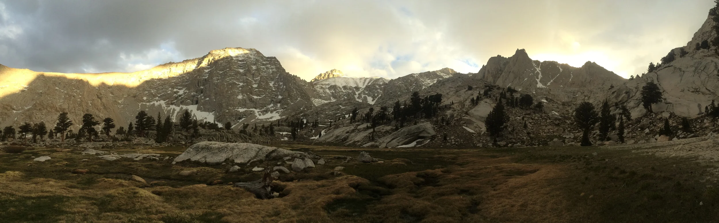
Snowfield in Consultation Lake drainage, June 2011

At 14,505 feet, Mt. Whitney is the highest peak in the continental United States. As the “highest peak”, it carries a certain amount of mountaineering cache. How much mountaineering cache? Well, that depends on what kind of a mountaineer one aspires to be; and when one climbs the mountain. Some mountaineers dismiss the peak as a “walk-up” because in July and August when the snow melts, a summit attempt only requires hiking eleven miles to the summit and eleven miles back down to the trailhead, which requires no technical climbing skills at all. From late fall to mid-summer, when the trail is covered with snow, the peak is not a mere “walk-up”, and technical skills are required to traverse snowfields safely while climbing up to the summit. I’ve been on the peak – and on the mountain a number of times, and what I can say about the mountain is this: there are prettier mountains; there are uglier mountains; it can be a place of mystic serenity; and it can be a place of brutal despair; but even though I’ve summited it seven times, I keep going back because it’s there, and because I like to go to the mountains to seek their tidings for my own inner peace.

But let’s talk about the facts about Mt. Whitney. Assuming you are taking the Whitney Portal Trail – the most popular trail, and the one that is run by a lottery, you are talking about over 6,000 feet of elevation gain to the summit; and 6,000 feet of elevation loss from the summit. You are talking about a total distance of twenty-two miles roundtrip. While these numbers won’t confuse anyone with the distances and the elevations gained and lost in the Himalayas, they’re nothing to take lightly either. This is to say nothing of the other hazards that you will encounter on the mountain: acclimatization issues, heatstroke, dehydration, hypothermia, weather, bears, and yes, marmots. (http://lastadventurer.com/last-adventurers-fieldnotes/2007/11/21/las-guide-to-summiting-whitney-part-v-minor-to-major-potenti.html).

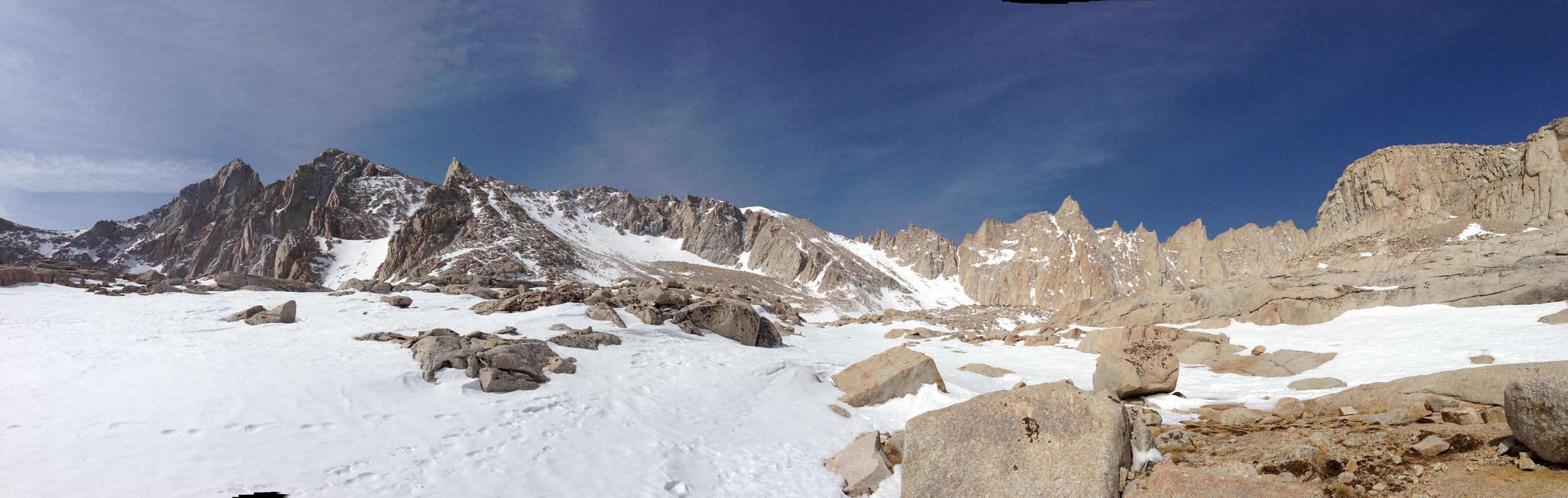
 The "chute", June, 2011

As I mentioned above, I’ve been on the peak a number of times (11); and I’ve summited seven times – this may seem like a lot, until you realize that other, more experienced climbers have been on the peak many more times than you (26 weeks in a row consecutively; 10 times in a week). The best things to know about Whitney are to know your limits and be prepared. What is the best resource for information about Mt. Whitney and current conditions? The Mt. Whitney Portal message board. Every time that I’ve climbed Mt. Whitney (in the internet age), this board has provided me with invaluable resources about conditions and what to expect. This information is crucial, because conditions vary on the mountain from day to day, and month to month. In 2001, when I summited Whitney, it was 95 degrees on the switchbacks – and it felt like 120 in the direct sun. In 2005, I couldn’t make it past Trail Camp in early May because I had no snowshoes, and was breaking trail the whole way. In 2007, when I backpacked up with a group, we had 50-70 mph winds ripping through our camp at Trail Camp all night before our summit bid the next day.

In 2009, I got off the summit just before clouds rolled in and the thundersnow began. In 2010 I got my group off of the summit and trail crest just as it began to snow on the day of the summer solstice. This is to say nothing of what happened in 2002, or any other year. In order to summit the mountain, you have to know the conditions, and be prepared for the conditions, as well as know your own physical condition and limits. Last year, in 2011, when I led my group up in mid-June (when all of these pictures were taken), there was still quite a bit of snow. In fact, there was more snow than when I had taken my group up on June 20, 2010. (Pictures here: http://lastadventurer.com/last-adventurers-fieldnotes/2010/7/1/mt-whitney-portal-to-summit-june-21-2010-part-two.html).

Looking back down the chute, June 2011

Like 2010, we had decided that we were going up the mountain in one day, and we were taking the main trail. Unlike 2010, however, we ran into snow covering the trail from a point just beyond Lone Pine Lake. At that point, it was no problem – since we had the proper gear and knowledge, we traversed firm, packed snow through the drainage of Consultation Lake up toward trail camp. We arrived at Trail Camp at around ~9 a.m., which we assumed would give us plenty of time to traverse the snow covering the “chute” to Trail Crest. However, unlike 2010, the snow in the chute was already warm and slightly sloppy at that time of day. The result? We spent a brutal two hours slogging through knee high soft snow to Trail Crest in the direct sun, which totally destroyed our energy levels.

After a rest, we headed out toward the summit along the backside. While my two climbing partners were still in good form, I was dragging. Even worse, having been up the summit seven times, I knew I was dragging. And this is where the first lesson about Mt. Whitney comes in: know your limits. In the 11 times I have been on the mountain, I have seen all sorts of crazy things, mostly involving people not being prepared, and not knowing their limits. Now, there’s a fine line here: as a mountaineer, you want to push yourself to accomplish your goal; but you also want to be safe. As Sir Edmund Hillary noted, a successful climb of any mountain involves descending. On Whitney, like any mountain, you have to know your limits, especially when risks like altitude sickness do exist. You have to know that when you are on the summit you are only halfway done with the hike. Think about that: on Whitney, when you are on the summit, you still have to descend 11 miles safely, which, like in 2011 and 2010, may be treacherous due to snow and ice. You have to apportion your energy accordingly, and know your limits.

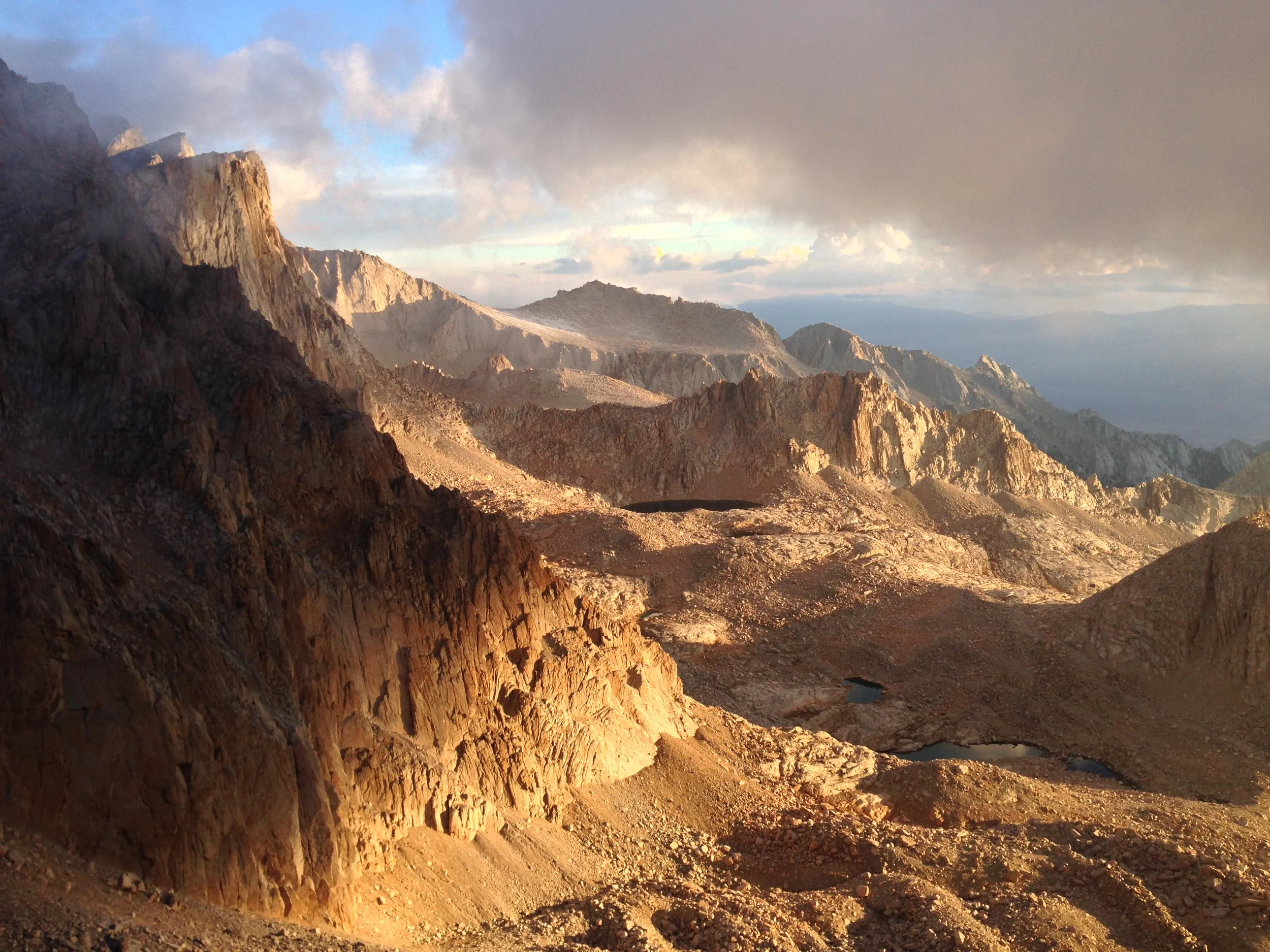
 West Side,Mt. Whitney Trail, June 2011

As for me in 2011, I sat down on the crest within a quarter mile of the summit (how do I know it was ¼ mile or less? Really? After being there past there 7 times, you know) and waited for my friends to come down. Could I have made it to the summit? Sure, I could have made it. Did I have to make it? No. Would anything bad have happened to me on the descent had I gone for it? Probably not. But stopping to rest; take in the view; and the mountain was the right decision and one that I would make again. (More on that here: http://youtu.be/Up-KyPn5Y8g). Was it easy? Nope, I am a very competitive person, and having been to the summit seven times before doesn’t make me less competitive, especially knowing how close I was. Still, it was the right decision, and next week I’ll be going back – and stay tuned to see where I end up on the mountain. But if you are considering attempting to summit, be prepared – and know your limits!

Current Conditions for 2012: There was not much snow this year in the Sierra, so from what I hear, the trail is pretty clear to Trail Camp. However, check back in next week for my report on the trail conditions. At this point, it still appears that you will need an ice axe, and crampons. 

Whitney Portal Message Boards: http://www.whitneyportalstore.com/forum/ubbthreads.php?ubb=postlist&Board=1&page=1