Carlsbad Flower Fields

Carlsbad Flower Fields

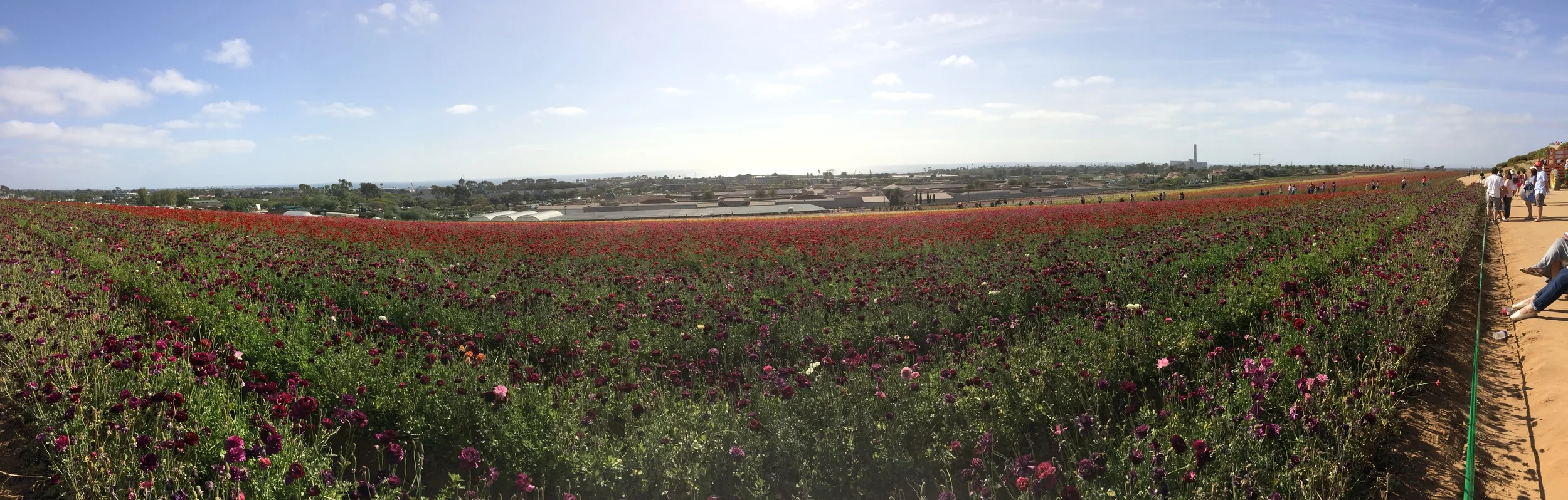
Even though it may seem hard to believe, California for much of the twentieth century and periods before was a large agricultural zone. Areas like “Orange County” and “Lemon Grove” were named because of the large commercial agricultural operations that occurred in those areas. As a matter of fact, Disneyland was constructed on one hundred and sixty acres of land that was occupied by orange groves and walnut trees. While most of this land has been swallowed up by urban development, large agricultural zones remain today in the Central Valley, and through the Coachella Valley regions. While a number of state parks in California cover the historical heritage of these agricultural ventures, San Diego is also home to a yearly agricultural spectacle of flowers at the Carlsbad Flower Fields.

Ballarat

Ballarat

One of the most desolate stretches of highway in California is the section of road on Highway 178 from Ridgecrest to Highway 190. To the North are the uninhabited regions of China Lake Naval Air Weapons Station and the Coso Wilderness. To the East are the high peaks of the Panamint Mountain range, and not one, but two salt flat laden valleys, the Searles Valley, and the Panamint Valley. There is only one “town” – in this area, and that is Trona, and it has seen better days. There is no cellular service on this stretch of highway, and during the summer, temperatures regularly exceed 115 degrees. The area is wild, and beautiful in a desolate, endless desert type of way. Along with the town of Trona, the area is also littered with places and things that time has forgotten, like the Trona Pinnacles, and various old mines and mining claims.

Winter Climbing Rogers Peak

Winter Climbing Rogers Peak

The Route/Conditions: As I mentioned above, I chose Rogers Peak for my snow survey of Telescope because it was an “easy” way to get the information. While access to Rogers Peak is through a fire road, it is worth noting that in winter, nothing is “easy” as it seems. Also, I would be remiss if I did not mention that Rogers Peak is a 9,994 foot mountain, and like most things in life, “easy” is a subjective term that can mean many things to many people. Finally, for people that are not familiar with the area, Rogers Peak is one of three mountains in the Panamint Range of Death Valley that are generally climbed together – a sort of “three peaks in one day” challenge. The other two are, respectively Telescope Peak (the highest point in Death Valley at 11,043 feet), and Bennett Peak (9,980 feet). While Rogers can be climbed as part of the three Panamint Peak trifecta from the main Telescope Peak trail, it can also be climbed separately as a stand-alone mountain via the fire access road.

Sweetwater Bridge

Sweetwater Bridge

One of the more unique items to be found out in the East County of San Diego is a bridge that is not connected to a road, and at times, does not cross water. The Sweetwater Bridge was built in 1929 to bridge the Sweetwater River, and at the time connected both ends of Highway 94. While it may appear imposing at four hundred and sixty feet in length, and twenty-two feet in width, it was in actuality, a narrow bridge in 1929, and a narrow bridge through its eventual retirement in 1987. In 1987, the road was re-routed slightly and a new, modern bridge was built right next to it on Highway 94.

Farewell Spit

Farewell Spit

After all of the Lord of the Rings movies, and the Hobbit movies, much is made of New Zealand being exactly like Middle Earth, with rolling green hills, high snow-capped mountains, and lush forests and roaring rivers. While New Zealand has all of these things and more, it also has an area that appears to be lifted straight from the Sahara, or from one of the deep deserts of the world. That place is the Farewell Spit, a fifteen mile (25km) stretch of land that extends from the northern section of the South Island of New Zealand. And for those willing to explore it, the Farewell Spit features sand dunes, blowing sand storms, long stretches of sandy coast, wildlife, and hidden pools of water.

Palais de L'lle, Annecy

Palais de L'lle, Annecy

Annecy is a charming town at the base of the French Alps. Sometimes called the “Venice of the Alps”, Annecy has a number of historic structures and activities for the traveler. One of the more unique structures in the old town of Annecy is the Palais de l’Île, which sits in the middle of the River Thiou. Built in the mid-twelfth century to control access to the river, and house prisoners, this small castle was later used as a mint in the fourteenth century. From the fourteenth century on, this castle was used for a number of things, including a prison through the Second World War. Following an extensive renovation, the Palais de l’Île now houses a museum featuring permanent exhibits about the history of the region, along with various traveling exhibits.

How to Explore Tortuguero

How to Explore Tortuguero

Tortuguero is a town and a National Park on the Caribbean coastline of Costa Rica; and it is also one of the best destinations to visit in the country, as it provides a plethora of unique wilderness experiences for all levels of visitors. While all of Costa Rica’s national parks are stunning, Tortuguero National Park is perhaps the country’s most pristine national park. Tortuguero National Park has an enormous amount of biodiversity including mangrove forests, beaches, swamps, lagoons, and of course, tropical rainforests. While the park protects many species of animals and plants, the main species (and attraction) that is protected is the Green Sea Turtle, which nests on the beaches of the park from July to October.